
Lunar Eclipses: 1941 - 1950
Fred Espenak
Introduction
A concise summary of all lunar eclipses from 1941 through 1950 is presented here in two ways. The first is a series of Figures showing the Moon's path through Earths shadows for each eclipse. The second is a Table listing the primary characteristics of each eclipse. Near the bottom of the page are a series of Links to more on lunar eclipses.
Figures of Lunar Eclipses: 1941 - 1950
The figures below offer a concise summary of all lunar eclipses from 1941 through 1950 . Each figure consists of a diagram showing the Moon's path through Earth's shadows and a map depicting the geographic region of visibility for a single eclipse. Click on an eclipse figure to link to a web page with complete details about that eclipse, including a larger version of the figure. Visit the Key to Lunar Eclipse Figures for a detailed explanation of these figures.
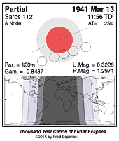
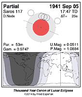
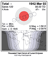
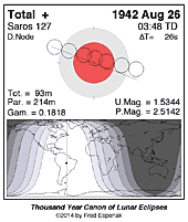
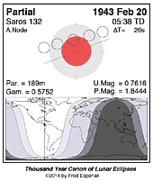
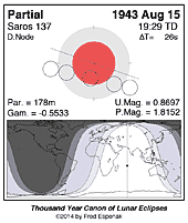
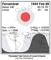
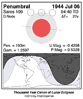
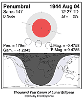
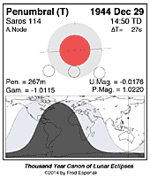
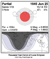
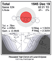
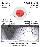
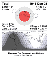
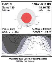
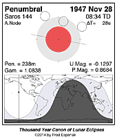
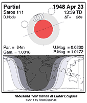
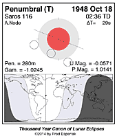
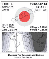
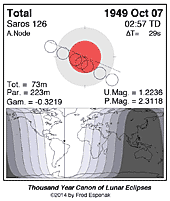

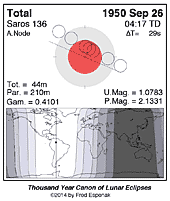
Table of Lunar Eclipses: 1941 through 1950
A concise summary of all lunar eclipses from 1941 through 1950 is presented in the table below. The first column gives the Calendar Date of the instant of greatest eclipse. The second column TD of Greatest Eclipse is the Terrestrial Dynamical Time (TD) when the Moon passes closest to the axis Earth's shadow. The third column lists the Eclipse Type which is either Total, Partial, or Penumbral.
Eclipses recur over the Saros cycle, a period of approximately 18 years 11 days. Each eclipse belongs to the Saros Series shown in column 4. The Umbral Magnitude gives the fraction of the Moon's diameter immersed in Earth's umbral shadow at the instant of greatest eclipse (column 5). The Eclipse Duration gives the length of the partial eclipse. If the eclipse is total then two durations are listed. The first is the interval between the beginning and end of the partial phases. The second value (in bold) is the duration the total phase (column 6). Finally, the Geographic Region of Eclipse Visibility provides a brief description of where each eclipse will be seen.
The eclipse date (first column) links to the prime page for the eclipse. This page features an eclipse diagram and map showing the geographic region of eclipse visibility, as well as detailed predictions, Besellian elements and links to additional information about the eclipse.
The Key to Lunar Eclipse Decade Table contains a more detailed description of each item in the table.
| Lunar Eclipses: 1941 - 1950 | ||||||
| Calendar Date | TD of Greatest Eclipse | Eclipse Type | Saros Series | Umbral Magnitude | Eclipse Duration | Geographic Region of Eclipse Visibility |
| 1941 Mar 13 | 11:55:47 | Partial | 112 | 0.323 | 02h00m | Asia, Australia, North America, western South America |
| 1941 Sep 05 | 17:47:14 | Partial | 117 | 0.051 | 00h53m | Europe, Africa, Asia, Australia, |
| 1942 Mar 03 | 00:21:54 | Total | 122 | 1.561 | 03h40m 01h36m |
Americas, Europe, Africa, Asia, western Australia |
| 1942 Aug 26 | 03:48:25 | Total | 127 | 1.534 | 03h34m 01h33m |
Americas, Europe, Africa |
| 1943 Feb 20 | 05:38:23 | Partial | 132 | 0.762 | 03h09m | Americas, Europe, Africa, western Asia |
| 1943 Aug 15 | 19:28:46 | Partial | 137 | 0.870 | 02h58m | eastern South America, Europe, Africa, Asia, Australia |
| 1944 Feb 09 | 05:14:57 | Penumbral | 142 | -0.522 | - | North Asia, Americas, Europe, Africa |
| 1944 Jul 06 | 04:40:01 | Penumbral | 109 | -0.440 | - | Americas, western Europe, Africa |
| 1944 Aug 04 | 12:26:52 | Penumbral | 147 | -0.476 | - | eastern Asia, Australia, western Americas |
| 1944 Dec 29 | 14:49:35 | Penumbral | 114 | -0.018 | - | Europe, eastern Africa, Asia, Australia, North America |
| 1945 Jun 25 | 15:14:22 | Partial | 119 | 0.859 | 03h13m | eastern Africa, Asia, Australia, western North America |
| 1945 Dec 19 | 02:20:47 | Total | 124 | 1.342 | 03h25m 01h19m |
Americas, Europe, Africa, eastern Asia |
| 1946 Jun 14 | 18:39:17 | Total | 129 | 1.398 | 03h49m 01h31m |
eastern South America, Europe, Africa, Asia, Australia, |
| 1946 Dec 08 | 17:48:28 | Total | 134 | 1.164 | 03h15m 00h57m |
North North America, Europe, Africa, Asia, Australia |
| 1947 Jun 03 | 19:15:43 | Partial | 139 | 0.020 | 00h35m | eastern South America, Europe, Africa, Asia, Australia |
| 1947 Nov 28 | 08:34:28 | Penumbral | 144 | -0.130 | - | eastern Asia, eastern Australia, Americas, western Africa, western Europe |
| 1948 Apr 23 | 13:39:19 | Partial | 111 | 0.023 | 00h34m | eastern Africa, Asia, Australia, western North America |
| 1948 Oct 18 | 02:35:41 | Penumbral | 116 | -0.057 | - | Americas, Europe, Africa, western Asia |
| 1949 Apr 13 | 04:11:25 | Total | 121 | 1.425 | 03h26m 01h25m |
Americas, Europe, Africa |
| 1949 Oct 07 | 02:56:55 | Total | 126 | 1.224 | 03h43m 01h13m |
Americas, Europe, Africa, western Asia |
| 1950 Apr 02 | 20:44:34 | Total | 131 | 1.033 | 03h10m 00h27m |
eastern South America, Europe, Africa, Asia, Australia |
| 1950 Sep 26 | 04:17:11 | Total | 136 | 1.078 | 03h30m 00h44m |
Americas, Europe, Africa, western Asia |
Geographic abbreviations (used above): n = north, s = south, e = east, w = west, c = central
Decade Tables of Lunar Eclipses
Each link in the following table displays a page containing 10 years of lunar eclipses. Every eclipse has links to an eclipse diagram and map of geographic visibility, and a dedicated web page for that eclipse.
| Decade Tables of Lunar Eclipses | |||||
| Decades | |||||
|---|---|---|---|---|---|
| 1901-1910 | 1911-1920 | 1921-1930 | 1931-1940 | 1941-1950 | |
| 1951-1960 | 1961-1970 | 1971-1980 | 1981-1990 | 1991-2000 | |
| 2001-2010 | 2011-2020 | 2021-2030 | 2031-2040 | 2041-2050 | |
| 2051-2060 | 2061-2070 | 2071-2080 | 2081-2090 | 2091-2100 | |
Century Catologs of Lunar Eclipses
Each link in the following table displays a catalog containing 100 years of eclipses.
| Century Catalogs of Lunar Eclipses | |||||
| Centuries | |||||
|---|---|---|---|---|---|
| 1001-1100 | 1101-1200 | 1201-1300 | 1301-1400 | 1401-1500 | |
| 1501-1600 | 1601-1700 | 1701-1800 | 1801-1900 | 1901-2000 | |
| 2001-2100 | 2101-2200 | 2201-2300 | 2301-2400 | 2401-2500 | |
| 2501-2600 | 2601-2700 | 2701-2800 | 2801-2900 | 2901-3000 | |
For other centuries, see Six Millennium Catalog of Lunar Eclipses: -2999 to +3000
Links to Additional Lunar Eclipse Predictions
- Home - home page of EclipseWise with predictions for both solar and lunar eclipses
- Lunar Eclipses - primary page for lunar eclipse predictions
- Lunar Eclipse Links - detailed directory of links
- Six Millennium Catalog of Lunar Eclipses - including the years -2999 to +3000 (3000 BCE to 3000 CE)
- Saros Catalog of Lunar Eclipses - covers Saros series -40 through 190
- Javascript Lunar Eclipse Explorer - calculate all lunar eclipses visible from a city
- 21st Century Canon of Lunar Eclipses - link to the publication
- Thousand Year Canon of Lunar Eclipses 1501 to 2500 - link to the publication
- Five Millennium Canon of Lunar Eclipses -1999 to +3000 - link to the publication
- MrEclipse.com - Eclipse resources and tips on photography
- Lunar Eclipses for Beginners - a primer on lunar eclipse basics
- How to Photograph a Lunar Eclipse - instructions for imaging an eclipse of the Moon
- MrEclipse Photo Index - an index of lunar eclipse photographs
Eclipse Publications
by Fred Espenak
|
|
|
|
|
|
Eclipse Predictions
The eclipse predictions presented here were generated using the JPL DE406 solar and lunar ephemerides. The lunar coordinates have been calculated with respect to the Moon's Center of Mass.
Acknowledgments
Some of the content on this web site is based on the book Thousand Year Canon of Lunar Eclipses 1501 to 2500. All eclipse calculations are by Fred Espenak, and he assumes full responsibility for their accuracy.
Permission is granted to reproduce eclipse data when accompanied by a link to this page and an acknowledgment:
"Eclipse Predictions by Fred Espenak, www.EclipseWise.com"
The use of diagrams and maps is permitted provided that they are NOT altered (except for re-sizing) and the embedded credit line is NOT removed or covered.