
21st Century Canon of Solar Eclipses
By Fred Espenak
Standard Edition
Standard Edition Features |
Deluxe Edition
Deluxe Edition Features |
|
Standard Black & White Edition $24.99 
|
Deluxe Black & White Edition $32.99
|
|
Standard Color Edition $36.99
|
Deluxe Color Edition $49.99
|
|
The links above all go to Amazon.com. However, you can order these books from any Amazon worldwide.
Visit any other Amazon and enter the book title in the Amazon search window. |
Description
The 21st Century Canon of Solar Eclipses contains maps and data for all 224 solar eclipses occurring during the 100-year period from 2001 through 2100. The eclipse predictions are based on the Jet Propulsion Lab's DE405 - a computer ephemeris used for calculating high precision coordinates of the Sun and Moon for hundreds of years into the past and future.
Visit the following link to see the Table of Contents.
Section 1 of the Canon presents fundamental concepts including eclipse classification, the visual appearance of each type of eclipse, safe eclipse viewing tips, and how duration changes with distance from the central line. Section 2 discusses the eclipse the predictions, the constants used, time measurement and Delta T. A statistical analysis of eclipse frequency, extremes in eclipse magnitude, greatest central duration and quincena combinations are covered in Section 3. A concise explanation of the data contained in the solar eclipse catalog (Appendix A) and detailed descriptions of the solar eclipse maps (Appendices B, C and D) appear in Sections 4 and 5.
The primary content of the 21st Century Canon of Solar Eclipses resides in the four appendices. Appendix A is a comprehensive catalog listing the essential characteristics of each eclipse. These include the calendar date and time of greatest eclipse, Delta T, lunation number, Saros series, gamma, eclipse magnitude, geographic coordinates of greatest eclipse, Sun's altitude and azimuth, central path width and central line duration. Appendix B is an atlas of maps depicting the geographic regions of visibility of each eclipse. The zones of partial and central eclipse are plotted using an orthographic (global) map projection. The 224 maps are arranged twelve to a page permitting the assessment of eclipse visibility from any location on Earth.
The following three images are sample pages from Appendices B, C and D. Click on each to open a full-size, full-resolution sample.
Page from Appendix B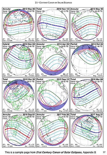
Page from Appendix B (click to enlarge) |
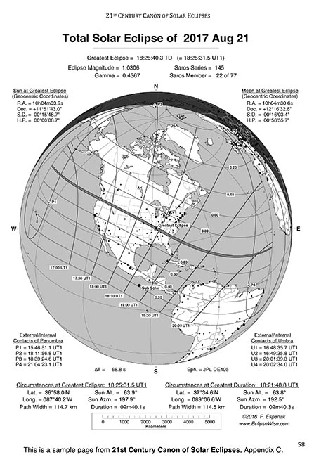
Page from Appendix C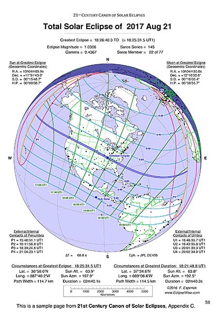
Page from Appendix C (click to enlarge) |
Page from Appendix D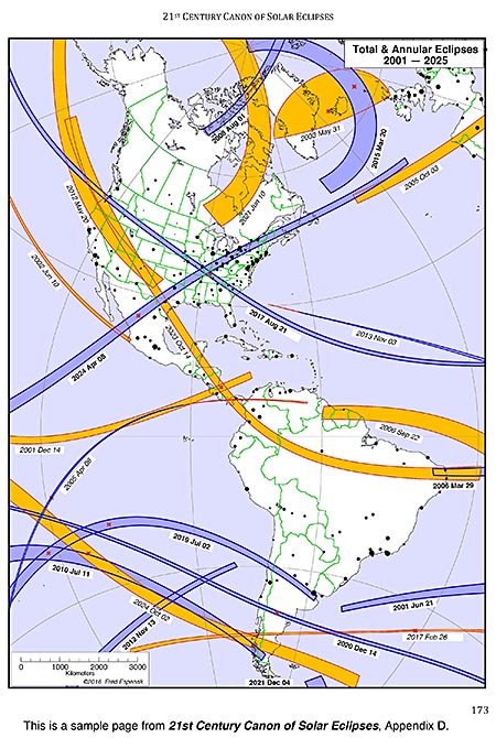
Page from Appendix D (click to enlarge) |
Appendix C contains zeros in on individual solar eclipses with a detailed full page map of each. Curves of Time of Maximum Eclipse and Curves of Constant Eclipse Magnitude permit the estimation of time and magnitude from any geographic location. Finally, Appendix D plots the track of every central eclipse (total, annular and hybrid) on large scale maps to allow the identification of countries and major cities within each eclipse path.
The 21st Century Canon of Solar Eclipses is available in two editions: 1) Standard Edition and 2) Deluxe Edition.
And each of them is available in either Black & White or Color.
The only difference between the two editions is in Appendix C.
In the Standard Edition, Appendix C contains 113 full-page maps - one for each solar eclipse from 2017 through 2066.
In comparison, Appendix C in the Deluxe Edition contains 224 full-page maps - one for each solar eclipse from 2001 through 2100.
Below is the key to the large global eclipse maps in Appendix C. It identifies the various curves and features in each map.
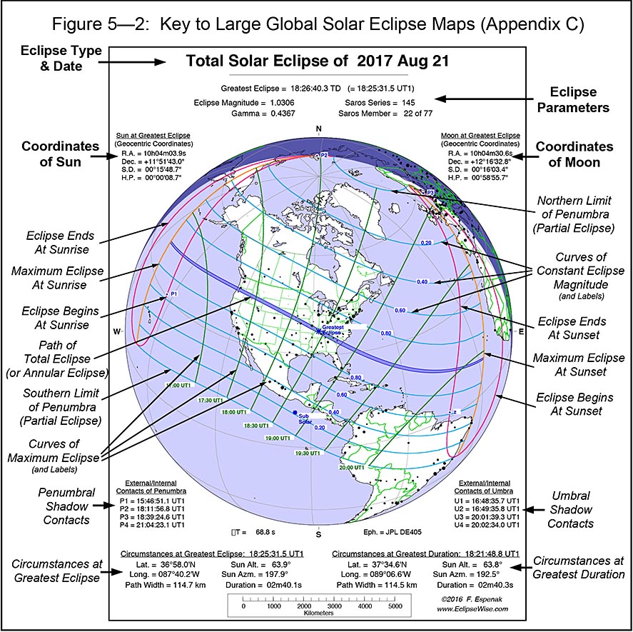
Key to Global Maps in Appendix C (click to enlarge) |
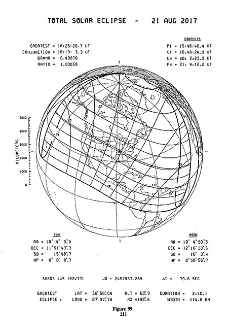
The 21st Century Canon of Solar Eclipses is the modern successor to the NASA publication Fifty Year Canon of Solar Eclipses. But the 21st Century Canon is much more that just an update. It covers an entire century rather than only 50 years. The global maps in Appendix C are larger with more detail and include positions of hundreds of cities. Compare the global maps of the 2017 total eclipse from the two canons below to see the improvement in the new canon.
Links for Ordering the 21st Century Canon of Solar Eclipses
Below are links for ordering each edition from Amazon.com:
- 21st Century Canon of Solar Eclipses - Standard Black & White Edition - $24.99 (186 pages)
- 21st Century Canon of Solar Eclipses - Standard Color Edition - $32.99 (186 pages)
- 21st Century Canon of Solar Eclipses - Deluxe Black & White Edition - $36.99 (296 pages)
- 21st Century Canon of Solar Eclipses - Deluxe Color Edition - $49.99 (296 pages)
|
The links above all go to Amazon.com. However, you can order these books from any Amazon worldwide.
Visit any other Amazon and enter the book title in the Amazon search window. |
About the Author
Click the following link to read a brief biography on Fred Espenak.
Also Available!
21st Century Canon of Lunar Eclipses
The 21st Century Canon of Lunar Eclipses contains figures, maps and data for all 228 lunar eclipses occurring during the 100-year period from 2001 through 2100. The eclipse predictions are based on the Jet Propulsion Lab's DE431 - a computer ephemeris used for calculating high precision coordinates of the Sun and Moon for hundreds of years into the past and future.
Section 1 of the Canon presents the fundamentals about lunar eclipses. Section 2 discusses the eclipse the predictions and the enlargement of Earth's shadows. An analysis of eclipse frequency, and the extremes in penumbral and umbral eclipse magnitudes, and durations of penumbral, partial and total eclipses are covered in Section 3.
The primary content of the "21st Century Canon" resides in the three appendices. Appendix A is a comprehensive catalog of lunar eclipses. Appendix B is an atlas of diagrams (12 per page) depicting the Moon's path through Earth's shadows and the geographic region of visibility of each eclipse. Appendix C zeros in on the lunar eclipses with a detailed full-page path diagrams and maps of each eclipse.
For more information visit 21st Century Canon of Lunar Eclipses.
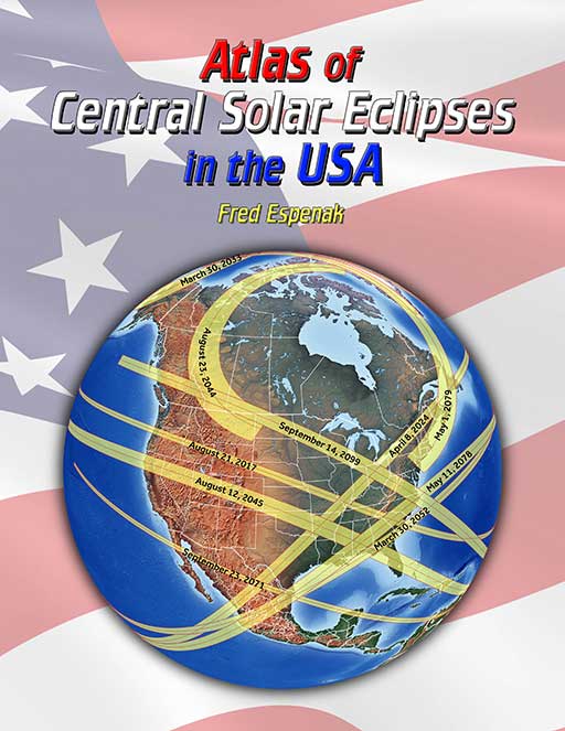
Atlas of Central Solar Eclipses in the USA
The Atlas of Central Solar Eclipses in the USA contains of a series of 499 global maps showing the geographic track of every total and annular solar eclipse across the USA (including Alaska and Hawaii) during the two-thousand-year period 1001 through 3000. It is accompanied by a catalog that lists the major characteristics of each eclipse including its duration and whether it is visible from the lower 48 states, Alaska and/or Hawaii.
A set of 20 detailed maps, each covering a 50-year period and centered on the lower 48 states, shows the path of every total and annular eclipse. The maps include state boundaries and major cities. These maps also cover southern Canada and northern Mexico.
For more information visit Atlas of Central Solar Eclipses in the USA.
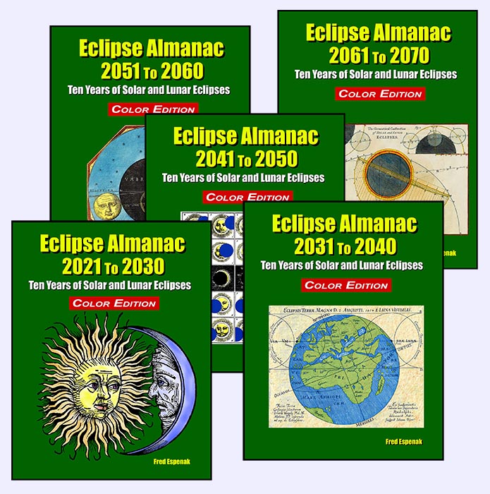
Eclipse Almanac
The Eclipse Almanac is a series of five publications. Each one is a concise reference for every eclipse of the Sun and the Moon over a 10-year period. This compendium identifies when and where each of these events will be seen. Particular details about each eclipse are included, as well as a 25-year table looking further into the future.
Section 1 presents solar eclipses including an explanation of why they occur, types of solar eclipses, and the visual appearance of each. Global maps depict the geographic regions of visibility of each of the 22 to 23 solar eclipses.
Section 2 covers lunar eclipses explaning why they occur, the types of lunar eclipses, and the appearance of each. Detailed figures illustrate each of the 22 to 23 lunar eclipses including the Moon's path through Earth's shadows, and a map of the geographic visibility of every eclipse.
Section 3 lists the date and time of the Moon’s phases over the decade.
The five volume Eclipse Almanac series covers the decades from 2021 to 2070.
For more information visit Eclipse Almanac.
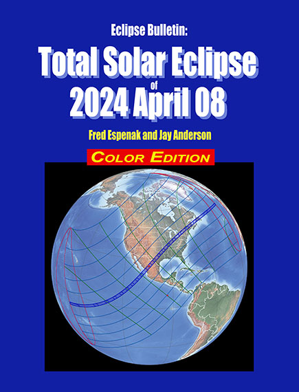
Eclipse Bulletin: Total Solar Eclipse of 2024 April 08
The Eclipse Bulletin: Total Solar Eclipse of 2024 April 08 is the complementary publication of the 2024 Road Atlas and is the ultimate guide to this highly anticipated event.
Eleven high resolution maps plot the total eclipse track across Mexico, the USA, and Canada. The large map scale (1 inch ≈ 53 miles) shows hundreds of cities and towns in the path, the location of major roads and highways, and the duration of totality with distance from the central line. Local circumstances tables for hundreds cities the USA, Canada, and Mexico provide times of each phase of the eclipse along with the eclipse magnitude, duration and Sun's altitude. A detailed climatological study identifies areas along the eclipse path where the highest probability of favorable weather may be found.
Finally, comprehensive information is presented about solar filters and how to safely observe the eclipse.
For more information visit Eclipse Bulletin: Total Solar Eclipse of 2024 April 08.
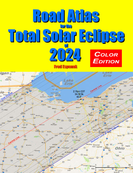
Road Atlas of the Total Solar Eclipse of 2024
The Road Atlas for the Total Solar Eclipse of 2024 contains a comprehensive series of 26 maps of the path of totality across Mexico, the USA and Canada. The large scale (1 inch ≈ 22 miles) shows both major and minor roads, towns and cities, rivers, parks, and mountains.
Although a partial eclipse will be seen from all of North America, the total phase in which the Moon completely covers the Sun (known as totality) will only be seen from within the 120-mile-wide path of the Moon’s umbral shadow as it sweeps across Mexico, the United States (Texas, Oklahoma, Arkansas, Missouri, Tennessee, Kentucky, Illinois, Indiana, Ohio, Michigan, Pennsylvania, New York, Vermont, New Hampshire, and Maine), and Canada (Ontario, Quebec, New Brunswick, Prince Edward Island, Nova Scotia and Newfoundland).
Armed with this atlas and the latest weather forecasts, the road warrior is ready to chase totality no matter where it takes him/her along the entire path. This mobile strategy offers the highest probability of witnessing the spectacular 2024 total eclipse in clear skies.
For more information visit Road Atlas for the Total Solar Eclipse of 2024.
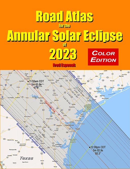
Road Atlas of the Annular Solar Eclipse of 2023
The Road Atlas for the Annular Solar Eclipse of 2023 contains a series of 29 maps of the path of annularity across the USA, Mexico, Central and South America. The large scale (1 inch ≈ 28 miles) shows both major and minor roads, towns and cities, rivers, parks, and mountains.
The annular eclipse phase in which the Moon is completely silhouetted in front of the Sun (known as annularity) will only be seen from within the 115 to 137 mile-wide path of the Moon’s antumbral shadow as it sweeps across the United States (Oregon, California, Idaho, Nevada, Utah, Colorado, Arizona, New Mexico, and Texas), Mexico, Central and South America.
Armed with this atlas and the latest weather forecasts, the road warrior is ready to chase annularity no matter where it takes him/her along the entire path. This mobile strategy offers the highest probability of witnessing the amazing 2023 annular eclipse in clear skies.
For more information visit Road Atlas for the Annular Solar Eclipse of 2023.
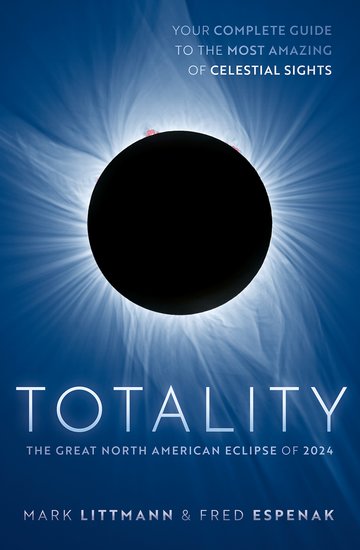
Totality - The Great North American Eclipse of 2024
The Totality - The Great North American Eclipse of 2024 is a complete guide to the spectacular total eclipse of April 8, 2024 that passes across the United States, Mexico and Canada. The book provides information, photographs, and illustrations to help understand and safely enjoy all aspects of this eclipse including:
- How to observe a total eclipse of the Sun
- How to photograph and video record an eclipse
- Why solar eclipses happen
- The earliest attempts to understand and predict eclipses
- The mythology and folklore of eclipses
- The response of man to total eclipses through time
- How scientists used total eclipses to understand how the Sun works
- How astronomers used a total eclipse to confirm Einstein's general theory of relativity
- Weather prospects for the 2024 eclipse
- Detailed maps of the path of totality for the 2024 eclipse
- Precise local times for the 2024 eclipse (the next total solar eclipse to visit the U.S.)
- Color and black-and-white photographs, diagrams, and charts to illustrate and explain total solar eclipses
- Global maps of total solar eclipses from 2024 to 2045 and lists of total and annular solar eclipses from 1970 through 2070
For more information visit Totality - The Great North American Eclipse of 2024.