
2017 Total Solar Eclipse in Missouri
by Fred Espenak
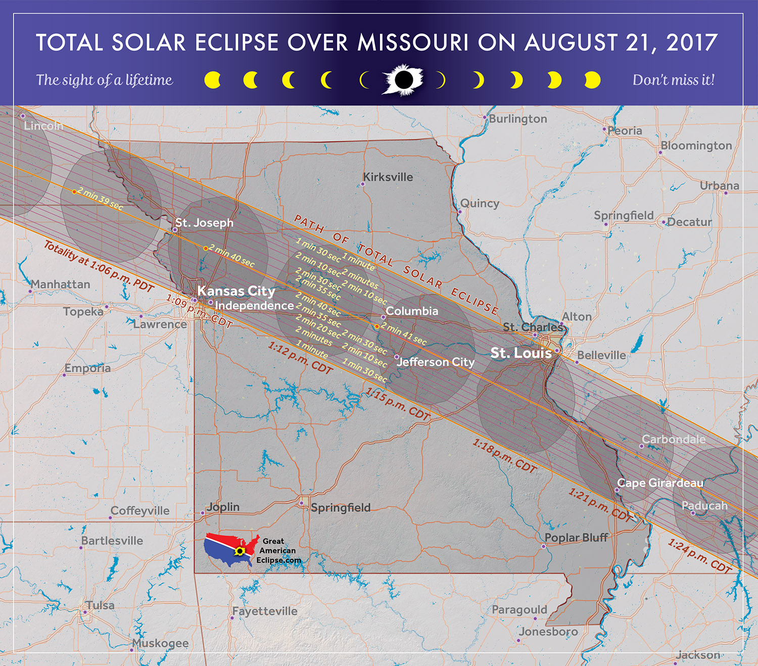
The 2017 Eclipse Path in Missouri
Map courtesy of Michael Zeiler
GreatAmericanEclipse.com
The 2017 Total Solar Eclipse in Missouri
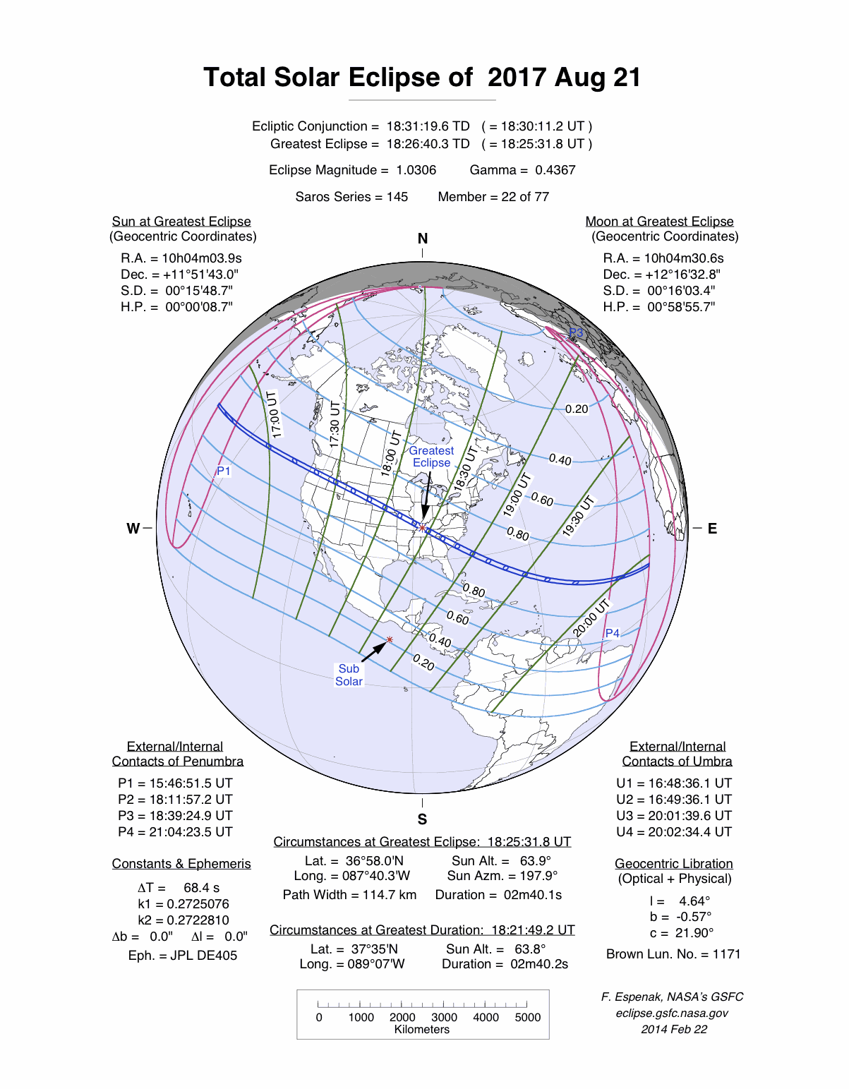
On 2017 August 21, a total eclipse of the Sun is visible from within a narrow corridor that traverses the United States of America. The path of the Moon's umbral shadow begins in northern Pacific and crosses the USA from west to east through parts of the following states: Oregon, Idaho, Wyoming, Nebraska, Kansas, Missouri, Illinois, Kentucky, Tennessee, North Carolina, Georgia, and South Carolina (a tiny corner of Montana and Iowa are also in the path). A partial eclipse visible from a much larger region covering all of North America (See Map).
The Moon's shadow straddles the border between Kansas and Missouri as it leaves Nebraska. Only the northeastern corner of Kansas falls within the umbra's path. Kansas City, the state's third largest city (pop. 148,400), straddles the eclipse track's southern limit. Consequently, the duration of totality ranges from zero (partial eclipse only) to over a minute depending on the observer's exact location. Note that the eastern half of the city is actually in the state of Missouri.
In Missouri, the Missouri River crisscrosses the central line several times as the umbra engulfs Columbia (pop. 115,300) and Jefferson City (pop. 43,300). The central line passes between the two municipalities whose inhabitants witness a total eclipse lasting two and a half minutes or more. Further east, St. Louis (pop. 318,400) is bisected by the track's northern limit. As with Kansas City, the duration of totality depends on one's exact position with northern locations only experiencing a partial eclipse.
Safe Eclipse Viewing
Every total eclipse of the Sun begins and ends with a partial eclipse. The partial phases require either a projection technique or a special solar filter to be viewed safely. Read more about this at Safe Solar Eclipse Viewing.
Of course during the few brief minutes of Totality when the Sun's disk is completely covered by the Moon, it is then safe to look directly at the Sun with the naked eye or through a telescope or binoculars.
Weather Prospects in Missouri and Illinois
(Excerpts from Eclipse Bulletin: Total Solar Eclipse of 2017 August 21)
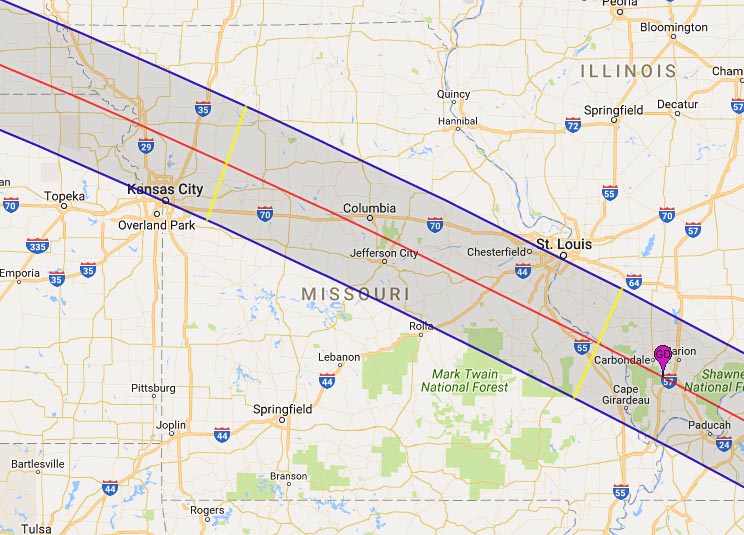
The portion of the eclipse track through Missouri and Illinois could very well be called the "river" section, as it follows the Missouri River to the Mississippi River, and then passes over the lower Ohio River on its path across Illinois. Because so much of the track is along or across these rivers, it’s generally a lowland transit along the central line, except in southeast Missouri. There, the south side of the track skirts the Ozark Plateau and then passes over the 1700-foot-high St. Francois Mountains before descending onto the floodplain of the Mississippi and Ohio Rivers, where elevations are about 1300 feet lower.
Average August afternoon cloud cover across Missouri and Illinois is nearly constant, at around 65% in the satellite-based statistics, a feature that is mirrored by weather-station observations from the ground. From the satellite viewpoint, the highest cloud levels on the central line occur south of St. Louis, near Festus, which is probably showing the influence of the nearby St. Francois Mountains. August cloud is typically convective cloud, usually building in the afternoon and settling overnight, though this is the general pattern and often interrupted by stronger weather systems that keep thunder and lightning going all through the night.
Meteorological data reveals that the average cloudiness is close to 50% across lowland Missouri but the percent of possible sunshine is still a promising 65% or thereabouts. Satellite and surface-station observations do not distinguish between opaque and transparent cloud, and so the relatively large sunshine readings are not surprising - some portion of it will come from semi-transparent clouds through which the Sun can shine and record its presence on the instruments. Just remember that cloud statistics - surface and satellite - should be used to compare one site with another and not to decide on the absolute probability of seeing the eclipse. That latter probability is best derived from the sunshine data, but even then, only imperfectly.
After crossing the St Francois Mountains, the track descends to the Mississippi and Ohio valleys and across the Big Muddy Watershed, where the average cloud cover declines once again. It’s only a ~5% decline, but it comes at a propitious place: near Carbondale, IL. Carbondale could justifiably be called America’s "Eclipse City," for it lies at the point where the eclipse tracks of 2017 and 2024 cross.
During the summer months, hot and muggy weather from the Gulf of Mexico is entrenched over Missouri and Illinois. Afternoon temperatures average close to 90 degrees and relative humidities hover near 50%. Such energy-sapping weather often persists for days, but in late August, relief comes irregularly when cool and dry air masses push southward from Canada and the Upper Midwest to bring a break in the sultry weather. For those not familiar with Midwest weather, the humid conditions will prove a challenge. These conditions are also important elements in thunderstorm development, though by August, the frequency of severe storms at least is much less than at its peak in May and June; tornadoes are quite uncommon in the month.
A great source of weather forecasts in the days leading up to the eclipse is Jay Anderson's Eclipsophile.com.
Excerpts from Eclipse Bulletin: Total Solar Eclipse of 2017 August 21. This material may not be reproduced without permission.
Fun Facts for the 2017 Total Eclipse in Missouri
- Across Missouri (from west to east) the width of the path of totality grows from 70.3 to 71.1 miles.
(average width is 70.7 miles) - The central line duration of totality increases from 2 minutes 38 seconds to 2 minutes 40 seconds across Missouri (from west to east).
- Across Missouri (from west to east) the speed of the Moon's shadow decreases from 1497 to 1465 mph.
(average speed is 1481 mph) - The center of the Moon's shadow sweeps across entire state of Missouri (from west to east) in just 12 minutes 08 seconds (a distance of 299 miles).
- The central line of the eclipse crosses from Kansas into Missouri, then back into Kansas and before finally returning to Missouri. This is because of a big meander in the Missouri River surrounding Rosecrans Memorial Airport in Missouri.
- Before 2017, the last two total solar eclipses visible from Missouri were on 1869 Aug 01 and 1806 Jun 16.
- After 2017, the next two total solar eclipses visible from Missouri will be on 2024 Apr 08 and 2178 Jun 16.
Eclipse Viewing Events and Local Pages in Missouri
- St. Joseph Eclipse Viewing - Rosecrans Memorial Airport, St. Joseph, MO
- St. Joseph - St. Joseph, MO
- 2017 Eclipse & 150 Years Festival - Lathrop, MO
- Lawson Eclipse (Facebook) - Lawson, MO
- Capital Eclipse Moon River Festival - Jefferson, MO
- Missouri State Parks (Facebook) - Missouri State Park
- Eclipse Page - Sullivan, MO
- Eclipse Page - St. Clair, MO
- Eclipse Page - St. Charles County, MO
- Eclipse Page - Herculaneum, MO
- Eclipse Page - Perryville, MO
- List of Eclipse Viewing Events - American Astronomical Society (AAS)
- List of Eclipse Viewing Events - NationalEclipse.com
- Eclipse Communities in Missouri - Eclipse2017.org
- If you know of other public eclipse viewing events in Missouri, send them to EclipseWise.
- Camp sites at Missouri State Parks can be reserved no more than nine months in advance
(Nov. 17, 2016 is nine months before the eclipse) - Campgrounds run by U.S. Forest Service can be reserved no more than six months in advance
(Feb. 17, 2017 is six months before the eclipse) - The partial phases require either a projection technique or a special solar filter to be viewed safely. On the other hand it is completely safe to watch Totality with the naked eye. For more information see Safe Solar Eclipse Viewing.
Google Map of 2017 Total Eclipse in Missouri
Google Map of 2017 Total Eclipse in Missouri
(Click to use interactive map)
The map above links to an interactive Google map showing the visibility of the Total Solar Eclipse of 2017 Aug 21 in Missouri. The interactive map allows the user to zoom and drag the map as desired. Click the cursor on any location to generate eclipse circumstances from that location.
Eclipse Circumstances for Cities in Missouri
The table below lists eclipse circumstances for a number of cities in Missouri. The following information is given for each city.
- The type of eclipse seen from the city (Partial or Total).
- The times when the partial eclipse begins and ends.
- The times when the total eclipse begins and ends.
- The time of maximum eclipse.
- The altitude on the Sun above the horizon (in degrees) at each of these times.
- The Eclipse Magnitude at maximum eclipse. Eclipse Magnitude is the fraction of the Sun’s diameter occulted by the Moon.
- The Eclipse Obscuration at maximum eclipse. Eclipse obscuration is the fraction of the Sun’s area occulted by the Moon.
- The Duration Total Eclipse is the length of the total phase in minutes and seconds (i.e., totality).
The times appearing in this table include Daylight Saving Time (DST) for all cities in which DST is observed. Report time zone or DST corrections for any city to EclipseWise.
Thanks to Bill Kramer (Eclipse-Chasers.com) for helping to develop the code to generate the above eclipse circumstances table. To calculate predictions for other cities see 2017 Eclipse Circumstances Calculator.
The partial phases require either a projection technique or a special solar filter to be viewed safely. On the other hand it is completely safe to watch Totality with the naked eye. For more information see Safe Solar Eclipse Viewing.
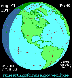
Animation of the Moon's Shadow Across Missouri
The animation above shows the Moon's umbral shadow as it tracks across Missouri. Observers must be inside this path to see the total eclipse. Outside the path only a partial eclipse is seen.
Animation courtesy of Michael Zeiler GreatAmericanEclipse.com.
States in the Path of Totality
The index below gives links to special pages for each of the 12 states in the path of the 2017 total solar eclipse. Note that the eclipse path also crosses a tiny corner of Montana and Iowa, but they are not included in this table.
| States in the Path of Totality | ||
Georgia |
Kentucky |
Oregon |
Idaho |
Missouri |
South Carolina |
Illinois |
Nebraska |
Tennessee |
Kansas |
North Carolina |
Wyoming |
Publications on the 2017 Total Solar Eclipse
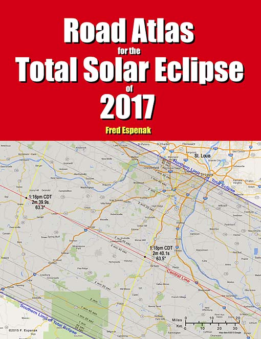
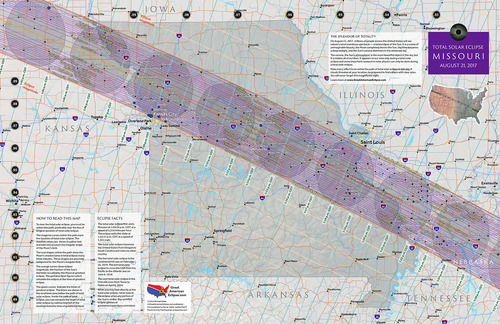
11" x 17" poster map of the 2017 eclipse path through Missouri
(GreatAmericanEclipse.com)
Additional Links for the 2017 Total Solar Eclipse
- Prime Page: Total Solar Eclipse of 2017 Aug 21 - EclipseWise general information on the eclipse
- Special News Page: Total Solar Eclipse of 2017 Aug 21 - major resources and links for the eclipse
- Orthographic Map: Total Solar Eclipse of 2017 Aug 21 - detailed map of eclipse visibility
- Animated Map: Total Solar Eclipse of 2017 Aug 21 - animated map of the Moon's shadows across Earth
- Google Map: Total Solar Eclipse of 2017 Aug 21 - interactive map of the eclipse path
- Path Table: Total Solar Eclipse of 2017 Aug 21 - coordinates of the central line and path limits
- Circumstances Table: Total Solar Eclipse of 2017 Aug 21 - eclipse times for hundreds of cities
- Saros 145 Table - data for all eclipses in the Saros series
- Total Solar Eclipse of 2017 Aug 21 - Google search for links to this eclipse
- 2017 Eclipse - American Astronomical Society (AAS)
- 2017 Eclipse in Missouri - GreatAmericanEclipse.com
- Detailed map of the 2017 eclipse path through Missouri - GreatAmericanEclipse.com
- Eclipse Communities in Missouri - Eclipse2017.org
- Eclipsophile.com - Weather for the 2017 Eclipse

Safe Solar Eclipse Glasses |

Rainbow Symphony Eclipse Shades |

Thousand Oaks Optical Solar Filters |

Great American Eclipse Store |
Links to Additional Solar Eclipse Information
- Home - home page of EclipseWise with predictions for both solar and lunar eclipses
- Solar Eclipses - primary page for solar eclipse predictions
- Solar Eclipse Links - detailed directory of links
- 21st Century Catalog of Solar Eclipses - including the years 2001 to 2100
- Total Solar Eclipses in the USA - maps for all total solar eclipses in the USA from 1001 to 3000
- Annular Solar Eclipses in the USA - maps for all annular solar eclipses in the USA from 1001 to 3000
- Hybrid Solar Eclipses in the USA - maps for all hybrid solar eclipses in the USA from 1001 to 3000
- Javascript Solar Eclipse Explorer - find all solar eclipses visible from a city
- MrEclipse.com - Eclipse resources and tips on photography
- Solar Eclipses for Beginners - a primer on solar eclipse basics
- Safe Solar Eclipse Viewing - summarizes several safe ways to view an eclipse of the Sun
- Solar Filter and Eclipse Glasses - a list of links
- Observing Solar Eclipses Safely - instructions for safely viewing an eclipse of the Sun
- How to Photograph a Solar Eclipse - instructions for imaging an eclipse of the Sun
- MrEclipse Photo Index - an index of solar eclipse photographs
Acknowledgments
Some in the JavaScript code used here is based on the work of Deirdre O'Byrne and Stephen McCann. Bill Kramer (Eclipse-Chasers.com) has expanded this code to work with dozens of cities.
The Besselian elements and values of ΔT used in these calculations are from Eclipse Bulletin: Total Solar Eclipse of 2017 August 21.
Permission is freely granted to reproduce this data when accompanied by an acknowledgment:
"Eclipse Predictions by Fred Espenak (EclipseWise.com)"