
2017 Total Solar Eclipse in Kentucky
by Fred Espenak
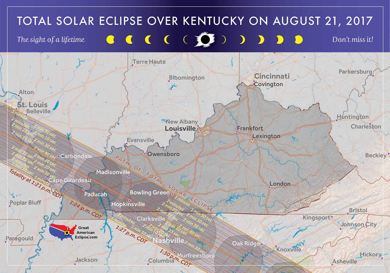
The 2017 Eclipse Path in Kentucky
Map courtesy of Michael Zeiler
GreatAmericanEclipse.com
The 2017 Total Solar Eclipse in Kentucky
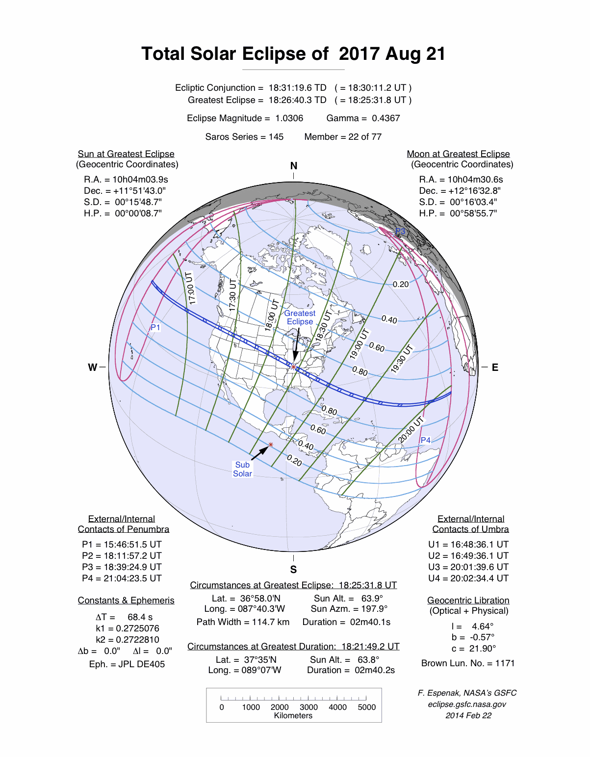
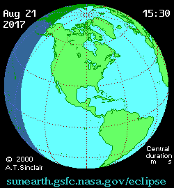
On 2017 August 21, a total eclipse of the Sun is visible from within a narrow corridor that traverses the United States of America. The path of the Moon's umbral shadow begins in northern Pacific and crosses the USA from west to east through parts of the following states: Oregon, Idaho, Wyoming, Nebraska, Kansas, Missouri, Illinois, Kentucky, Tennessee, North Carolina, Georgia, and South Carolina (a tiny corner of Montana and Iowa are also in the path). A partial eclipse visible from a much larger region covering all of North America (See Map).
A few minutes after entering Illinois, the shadow leaves the state as it crosses the Ohio River and arrives in Kentucky. It is here that the lunar shadow's axis makes its closest approach to Earth's center - the instant of greatest eclipse - at 18:25:32 UT1 (13:25:32 CDT). At this location (lat. = 36°58.0'N, long. = 087°40.3'W), totality lasts 2 minutes 40.1 seconds, the path width is 115 km (71 mi), the umbral velocity is 0.647 km/s (1447 mi/hr) and the Sun's altitude is 64°.
Hopkinsville (pop. 3,000) lies on the central line only 19 km (12 mi) southeast of greatest eclipse. The duration of totality here (the same as greatest eclipse) is within 0.1 second of the value of greatest duration near Carbondale, IL. Although some people are fixated on fractions of a second and the ultimate duration of totality in selecting an eclipse viewing site, these issues will fade into the noise as cloud avoidance and clear skies ascend to the rank of utmost importance on eclipse day. "A 30-second eclipse in a clear sky beats a 7-minute eclipse behind clouds."
Ever since its Oregon landfall 71 minutes earlier, the eclipse track has been gradually curving further and further south of east. Its azimuth is 115° as it crosses into Tennessee and the umbra begins the final 20 minutes of its trek through the USA.
Safe Eclipse Viewing
Every total eclipse of the Sun begins and ends with a partial eclipse. The partial phases require either a projection technique or a special solar filter to be viewed safely. Read more about this at Safe Solar Eclipse Viewing.
Of course during the few brief minutes of Totality when the Sun's disk is completely covered by the Moon, it is then safe to look directly at the Sun with the naked eye or through a telescope or binoculars.
Weather Prospects in Kentucky and Tennessee
(Excerpts from Eclipse Bulletin: Total Solar Eclipse of 2017 August 21)
It is early afternoon - around 1:30 pm - when the track reaches Kentucky and afternoon clouds, if there are any, will be building in the sky. Afternoons in Kentucky and much of Tennessee are no cloudier than the early morning according to observations from the weather satellites. What changes is the type of cloud: convective clouds build in the afternoon as the ground heats and warm thermals begin to rise. In contrast to eclipse sites in western states, the cloudiness measured in states east of the Mississippi shows a higher frequency of overcast conditions - just short of 20% of recordings in much of Tennessee and Kentucky. Compare this to just 10% to 15% in Wyoming and to 5% to 10% on the Columbia Plateau in Oregon.
The terrain across western Kentucky is relatively flat - a landscape of small, rolling hills that make up the Pennyroyal (Pennyrile) Plateau. Off the Interstates, roads are tree lined, limiting the view, but accompanied by generous openings that look across the many farms in the region. As the track enters Tennessee, the land begins to rise, crossing the low hills of the Highland Rim before dropping into the Nashville Basin.
Beyond Nashville, the track climbs the higher Cumberland Plateau, and then promptly sinks into the Tennessee Valley. In the satellite record, none of these ups and downs in the terrain have much influence on the cloud cover, which is high and climbing slowly, formed by the generous sub-tropical humidity of the area and a steady rise in the land's elevation toward the Appalachians. The surface observations are a little less daunting, showing a 12% decrease in average cloud cover at Chattanooga compared to the 58% at Nashville. Across both states, broken cloudiness is the dominant afternoon sky condition, while clear skies are uncommon - only 5% to 10% of the observations at eclipse time.
On the border with Georgia and the Carolinas, the track reaches the Blue Ridge Mountains, a section of the Appalachians, and both the terrain and average cloud cover climb sharply. This region has the highest cloud cover along the track, reaching nearly 80% in the satellite measurements. In the Moon's course across Kentucky and Tennessee, the percent of possible sunshine declines from a tolerable 71% at Paducah to 63% at Nashville, and presumably a fair bit lower over the Appalachians, though there are no measurements to show that.
A great source of weather forecasts in the days leading up to the eclipse is Jay Anderson's Eclipsophile.com.
Excerpts from Eclipse Bulletin: Total Solar Eclipse of 2017 August 21. This material may not be reproduced without permission.
Fun Facts for the 2017 Total Eclipse in Kentucky
- The axis of the Moon's shadow makes its closest approach to Earth's center - the instant of greatest eclipse - in western Kentucky 12 miles northwest of Hopkinsville at 1:25:32 pm CDT.
- The average width of the path of totality is 71.2 miles across Kentucky.
- The central line covers a distance of 97 miles across Kentucky.
- The average central line duration of totality is 2 minutes 40 seconds across Kentucky.
- The average speed of the Moon's shadow is 1449 mph across Kentucky.
- Before 2017, the last two total solar eclipses visible from Kentucky were on 1869 Aug 01 and 1717 Oct 04.
- After 2017, the next two total solar eclipses visible from Kentucky will be on 2024 Apr 08 and 2153 Oct 17.
Eclipse Viewing Events and Local Pages in Kentucky
- Eclipse Page (FaceBook) - Lyon County, KY
- SolQuest 2017 - Cerulean, KY
- Eclipse Page - Burdoc Farms, KY
- "Little Green Men" Days Festival - Kelly, KY
- Point of Greatest Eclipse - Hopkinsville, KY
- Eclipse Page - Christian Way Farm, KY
- Solar Eclipse Experience - Oak Grove, KY
- List of Eclipse Viewing Events - American Astronomical Society (AAS)
- List of Eclipse Viewing Events - NationalEclipse.com
- Eclipse Communities in Kentucky - Eclipse2017.org
- If you know of other public eclipse viewing events in Kentucky, send them to EclipseWise.
- Camp sites at Kentucky State Parks can be reserved no more than nine months in advance
(Nov. 17, 2016 is nine months before the eclipse) - Campgrounds run by U.S. Forest Service can be reserved no more than six months in advance
(Feb. 17, 2017 is six months before the eclipse) - The partial phases require either a projection technique or a special solar filter to be viewed safely. On the other hand it is completely safe to watch Totality with the naked eye. For more information see Safe Solar Eclipse Viewing.
Google Map of 2017 Total Eclipse in Kentucky
Google Map of 2017 Total Eclipse in Kentucky
(Click to use interactive map)
The map above links to an interactive Google map showing the visibility of the Total Solar Eclipse of 2017 Aug 21 in Kentucky. The interactive map allows the user to zoom and drag the map as desired. Click the cursor on any location to generate eclipse circumstances from that location.
Eclipse Circumstances for Cities in Kentucky
The table below lists eclipse circumstances for a number of cities in Kentucky. The following information is given for each city.
- The type of eclipse seen from the city (Partial or Total).
- The times when the partial eclipse begins and ends.
- The times when the total eclipse begins and ends.
- The time of maximum eclipse.
- The altitude on the Sun above the horizon (in degrees) at each of these times.
- The Eclipse Magnitude at maximum eclipse. Eclipse Magnitude is the fraction of the Sun’s diameter occulted by the Moon.
- The Eclipse Obscuration at maximum eclipse. Eclipse obscuration is the fraction of the Sun’s area occulted by the Moon.
- The Duration Total Eclipse is the length of the total phase in minutes and seconds (i.e., totality).
The times appearing in this table include Daylight Saving Time (DST) for all cities in which DST is observed. Report time zone or DST corrections for any city to EclipseWise.
Thanks to Bill Kramer (Eclipse-Chasers.com) for helping to develop the code to generate the above eclipse circumstances table. To calculate predictions for other cities see 2017 Eclipse Circumstances Calculator.
The partial phases require either a projection technique or a special solar filter to be viewed safely. On the other hand it is completely safe to watch Totality with the naked eye. For more information see Safe Solar Eclipse Viewing.
Animation of the Moon's Shadow Across Kentucky
The animation above shows the Moon's umbral shadow as it tracks across Kentucky. Observers must be inside this path to see the total eclipse. Outside the path only a partial eclipse is seen.
Animation courtesy of Michael Zeiler GreatAmericanEclipse.com.
States in the Path of Totality
The index below gives links to special pages for each of the 12 states in the path of the 2017 total solar eclipse. Note that the eclipse path also crosses a tiny corner of Montana and Iowa, but they are not included in this table.
| States in the Path of Totality | ||
Georgia |
Kentucky |
Oregon |
Idaho |
Missouri |
South Carolina |
Illinois |
Nebraska |
Tennessee |
Kansas |
North Carolina |
Wyoming |
Publications on the 2017 Total Solar Eclipse
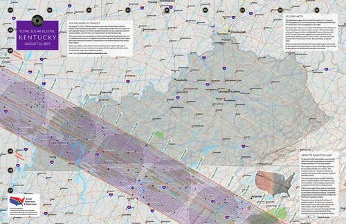
11" x 17" poster map of the 2017 eclipse path through Kentucky
(GreatAmericanEclipse.com)
Additional Links for the 2017 Total Solar Eclipse
- Prime Page: Total Solar Eclipse of 2017 Aug 21 - EclipseWise general information on the eclipse
- Special News Page: Total Solar Eclipse of 2017 Aug 21 - major resources and links for the eclipse
- Orthographic Map: Total Solar Eclipse of 2017 Aug 21 - detailed map of eclipse visibility
- Animated Map: Total Solar Eclipse of 2017 Aug 21 - animated map of the Moon's shadows across Earth
- Google Map: Total Solar Eclipse of 2017 Aug 21 - interactive map of the eclipse path
- Path Table: Total Solar Eclipse of 2017 Aug 21 - coordinates of the central line and path limits
- Circumstances Table: Total Solar Eclipse of 2017 Aug 21 - eclipse times for hundreds of cities
- Saros 145 Table - data for all eclipses in the Saros series
- Total Solar Eclipse of 2017 Aug 21 - Google search for links to this eclipse
- 2017 Eclipse - American Astronomical Society (AAS)
- 2017 Eclipse in Kentucky - GreatAmericanEclipse.com
- Detailed map of the 2017 eclipse path through Kentucky - GreatAmericanEclipse.com
- Eclipse Communities in Kentucky - Eclipse2017.org
- Eclipsophile.com - Weather for the 2017 Eclipse

Safe Solar Eclipse Glasses |

Rainbow Symphony Eclipse Shades |

Thousand Oaks Optical Solar Filters |

Great American Eclipse Store |
Links to Additional Solar Eclipse Information
- Home - home page of EclipseWise with predictions for both solar and lunar eclipses
- Solar Eclipses - primary page for solar eclipse predictions
- Solar Eclipse Links - detailed directory of links
- 21st Century Catalog of Solar Eclipses - including the years 2001 to 2100
- Total Solar Eclipses in the USA - maps for all total solar eclipses in the USA from 1001 to 3000
- Annular Solar Eclipses in the USA - maps for all annular solar eclipses in the USA from 1001 to 3000
- Hybrid Solar Eclipses in the USA - maps for all hybrid solar eclipses in the USA from 1001 to 3000
- Javascript Solar Eclipse Explorer - find all solar eclipses visible from a city
- MrEclipse.com - Eclipse resources and tips on photography
- Solar Eclipses for Beginners - a primer on solar eclipse basics
- Safe Solar Eclipse Viewing - summarizes several safe ways to view an eclipse of the Sun
- Solar Filter and Eclipse Glasses - a list of links
- Observing Solar Eclipses Safely - instructions for safely viewing an eclipse of the Sun
- How to Photograph a Solar Eclipse - instructions for imaging an eclipse of the Sun
- MrEclipse Photo Index - an index of solar eclipse photographs
Acknowledgments
Some in the JavaScript code used here is based on the work of Deirdre O'Byrne and Stephen McCann. Bill Kramer (Eclipse-Chasers.com) has expanded this code to work with dozens of cities.
The Besselian elements and values of ΔT used in these calculations are from Eclipse Bulletin: Total Solar Eclipse of 2017 August 21.
Permission is freely granted to reproduce this data when accompanied by an acknowledgment:
"Eclipse Predictions by Fred Espenak (EclipseWise.com)"