Eclipses During 2016
By Fred Espenak
Based on the Article Published in
Observer's Handbook 2016,
Royal Astronomical Society of Canada
In 2016, there are two solar eclipses and two penumbral lunar eclipses:
| Eclipses During 2016 | |||
| 2016 Mar 09: Total Solar Eclipse | |||
| 2016 Mar 23: Penumbral Lunar Eclipse | |||
| 2016 Sep 01: Annular Solar Eclipse | |||
| 2016 Sep 16: Penumbral Lunar Eclipse | |||
| Eclipses During 2016 | |||
|
Total Solar Eclipse 2016 Mar 09 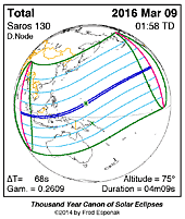
|
Penumbral Lunar Eclipse 2016 Mar 23 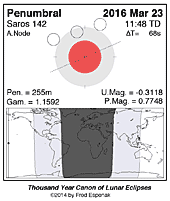
|
Annular Solar Eclipse 2016 Sep 01 
|
Penumbral Lunar Eclipse 2016 Sep 16 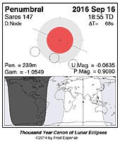
|
Predictions for the eclipses are summarized in Figures 1, 2, 3, and 4. World maps show the regions of visibility for each eclipse. The lunar eclipse diagrams also include the path of the Moon through Earth’s shadow. Contact times for each principal phase are tabulated along with the magnitudes and geocentric coordinates of the Sun and Moon at greatest eclipse.
All times and dates used in this publication are in Universal Time or UT. This astronomically derived time system is colloquially referred to as Greenwich Mean Time or GMT. To learn more about UT and how to convert UT to your own local time, see Time Zones and Universal Time.
Click for larger more detailed figure
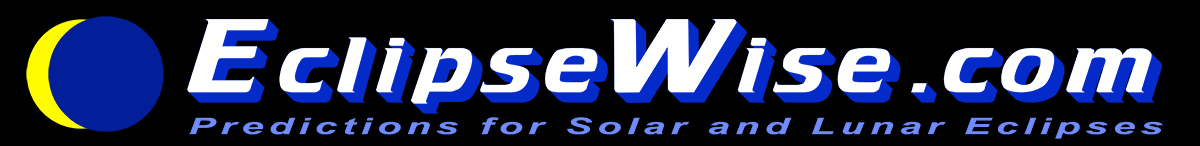
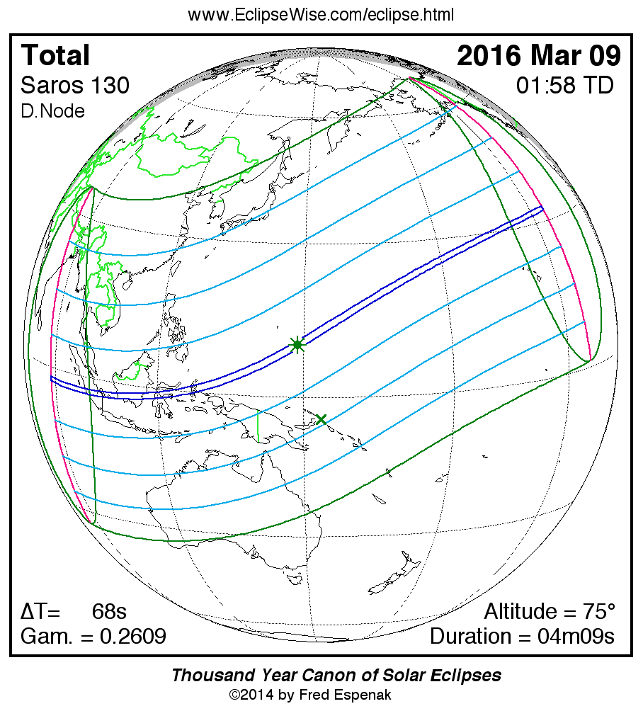
Total Solar Eclipse of 2016 Mar 09
The first eclipse of the year occurs in Aquarius at the Moon’s descending node just 1.2 days after the Moon reaches perigee. Such a close Moon during a total eclipse typically produces a long duration of totality - especially if the path passes near the Equator. In the case of the March 09 event, the maximum duration is just over 4 minutes.
The total eclipse is visible from within a narrow corridor that traverses Indonesia (including Sumatra, Borneo, Sulawesi and Halmahera) and the Pacific Ocean. A partial eclipse is seen within the much broader path of the Moon's penumbral shadow, which includes southeastern and eastern Asia, Oceana, most of Australia and the Pacific Ocean (Figure 1). The central path begins in the Indian Ocean about 1400 kilometers west of Sumatra at 00:17 UT1 [1]. The Moon’s umbral shadow makes first landfall in Sumatra at 00:19 UT1 and lasts 1 minute 56 seconds on the central line. The path width is then 108 kilometers and the Sun’s altitude is 14°.
The shadow engulfs Palembang before crossing the Banka Belitung Islands in the Java Sea. It sweeps through southern Borneo and traverses the Makassar Straight where more that 1000 eclipse chasers will be waiting aboard Holland America's Volendam. The central line duration here is 2 minutes 45 seconds with the Sun 30° above the eastern horizon.
The umbral track continues across Sulawesi, the Molucca Sea and North Miluku and the central line duration climbs above three minutes. Leaving Indonesia, the shadow travels northeast passing about 540 kilometers south of Guam, which experiences a partial eclipse of magnitude 0.868.
Greatest eclipse [2] occurs at 01:57:11 UT1 in the western Pacific. The central duration of totality is 4 minutes 09 seconds, the Sun’s altitude is 75°, the path width is 155 kilometers. The remaining 7,000+ kilometers of the path’s course is across open Ocean although it narrowly misses Wake Island (eclipse magnitude 0.992).
Continuing to curve north across the vast Pacific, the umbra passes 1100 kilometers north of the Hawaiian Islands where a partial eclipse of magnitude 0.703 is visible from Honolulu at 03:36 UT1. The path ends about 2400 kilometers west of Los Angeles, USA at 03:37 UT1 as the lunar shadow lifts off Earth and returns to space.
During the course of its 3 hour 21 minute trajectory, the umbra’s track is approximately 14,200 kilometers long and covers 0.36% of Earth’s surface area. Central line coordinates and circumstances are presented in Table 1.
Partial phases of the eclipse are visible primarily from southeastern and eastern Asia, Oceana, most of Australia (as well as Hawaii and Alaska). Local circumstances for a number of cities in these regions are found in Table 2. All times are given in Universal Time (UT1). The Sun's altitude and azimuth, the eclipse magnitude [3] and obscuration [4] are all given at the instant of maximum eclipse at each location.
The EclipseWise Javascript Solar Eclipse Explorer is an interactive web page that can quickly calculate the local circumstances for the eclipse from any geographic location not included in Tables 1 and 2:
Javascript Solar Eclipse Explorer: www.EclipseWise.com/solar/JSEX/JSEX-index.html
This is the 52nd eclipse of Saros 130 (Espenak and Meeus, 2006). All eclipses in this Saros series [5] occur at the Moon's descending node and gamma increases with each member in the family. The series is a mature one that began with a modest partial eclipse on 1096 Aug 20. After 21 partial eclipses in the series and nearly 3 centuries, the first umbral eclipse occurred on 1475 Mar 25. The event was a 2-minute total eclipse through the South Pacific. During the next 1 ½ centuries, the umbral duration continued to increase as each path shifted progressively northward. The greatest umbral duration of Saros 130 occurred during the total eclipse of 1619 Jul 11. Unfortunately, the 6 minute 41 second total eclipse was only visible from equatorial Africa, which was virtually inaccessible to astronomers of the day.
As the duration of each succeeding eclipse decreased, the paths reversed their northern migration and drifted southward during the 18th and 19th centuries. This effect occurred as a result of Earth's passage through winter solstice whereby the northern hemisphere tipped away from the Sun. A notable member of the series occurred on 1871 Dec 12. Spectroscopic observations of this event made by French astronomer Pierre Jules Janssen led him to propose that the corona is a physical part of the Sun and is composed of both hot gases and cooler particles. Together with observations of a later eclipse in 1778, it convinced Janssen that the shape of the corona is linked to the sunspot cycle.
The northbound trend of the Saros series resumed with the eclipse of 1908 Jan 3. At this point, the duration of totality at greatest eclipse had dropped to 4 minutes 14 seconds. The most recent member occurred on 1998 February 26 and its path crossed the Galapagos, Colombia, Venezuela, and the Caribbean. After 2016, the next member occurs on 2034 Mar 20 and passes through Nigeria, Cameroon, Chad, Sudan, Egypt, Saudi Arabia, Iran, Afghanistan, Pakistan, India, and China. On 2052 Mar 30, the series returns to the Western Hemisphere producing a path through central Mexico and the southeastern United States. The duration of totality drops as Saros 130 continues to produce total eclipses during the 22nd century. The last umbral eclipse of the series occurs on 2232 Jul 18 and lasts a maximum of 1 minute 14 seconds. The final 9 eclipses of the series are all partial events in the polar regions of the northern hemisphere. The family terminates with the partial eclipse of 2394 Oct 25.
Complete details for the 73 eclipses in the series (in the sequence 21 partial, 43 total, and 9 partial) may be found at:
www.EclipseWise.com/solar/SEsaros/SEsaros130.html
For additional details on this event, see the EclipseWise Prime Page on the Total Solar Eclipse of 2016 March 09.
Click for larger more detailed figure
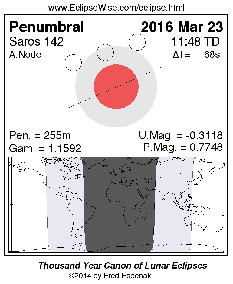
Penumbral Lunar Eclipse of 2016 Mar 23
The first lunar eclipse of the year occurs at the lunar orbit's ascending node in Virgo. The apparent diameter of the Moon is smaller than average since the eclipse occurs 2.1 days before apogee (Mar 25 at 14:17 UT1).
The Moon's orbital trajectory takes it through the northern part of Earth’s penumbral shadow as illustrated in Figure 2 along with a map illustrating worldwide visibility of the event.
The times of the major eclipse phases are as follows.
                              Penumbral Eclipse Begins:	    09:39:28 UT1
                              Greatest Eclipse:	            11:47:13 UT1
                              Penumbral Eclipse Ends:       13:54:54 UT1
At the instant of greatest eclipse (11:47:13 UT1), the Moon lies at the zenith for a point in the central Pacific near the Equator. The penumbral eclipse magnitude peaks at 0.7748 as southern parts of the Moon pass through the penumbral shadow.
Note that the beginning and end of a penumbral eclipse are not visible to the eye. In fact, no shading can be detected until about 2/3 of the Moon's disk is immersed in the penumbra. This would place the period of eclipse visibility within about 1/2 hour of greatest eclipse. Keep in mind that this is only an estimate. Atmospheric conditions and the observer's visual acuity are important factors to consider. An interesting exercise is to note when penumbral shading is first and last seen.
The entire event is visible from the Pacific Ocean, western North America, eastern Australia, New Zealand and Japan. Observers in eastern North and South America miss the late stages of the eclipse because they occur after moonset. Likewise parts of central and eastern Asia experience moonrise after the eclipse begins so they miss the early stages. None of the eclipse is visible from Europe or Africa.
The March 23 eclipse is the 18th eclipse of Saros 142. This series began on 1709 Sep 19 and is composed of 74 lunar eclipses in the following sequence: 21 penumbral, 7 partial, 26 total, 9 partial, and 10 penumbral eclipses (Espenak and Meeus, 2009a). The last eclipse of the series is on 3007 Nov 17.
Complete details for Saros 142 can be found at:
www.EclipseWise.com/lunar/LEsaros/LEsaros142.html
For additional details on this event, see the EclipseWise Prime Page on the Penumbral Lunar Eclipse of 2016 March 23.
Click for larger more detailed figure
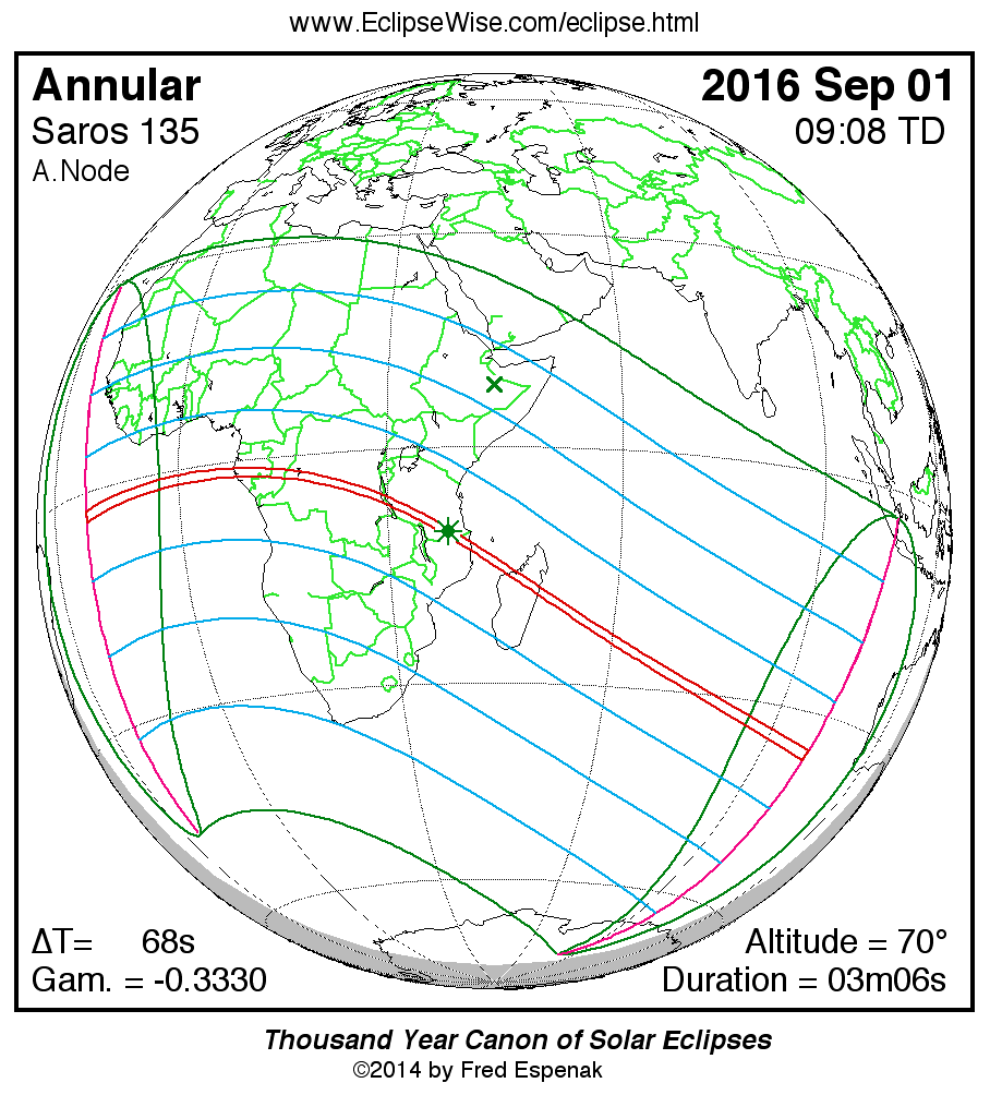
Annular Solar Eclipse of 2016 Sep 01
The second solar eclipse of 2016 occurs in Leo at the Moon’s ascending node about 5.4 days before apogee. The central track of the annular eclipse crosses central Africa and the Indian Ocean (Figure 3). Countries in the annular path include Gabon, Congo, Democratic Republict of the Congo, Tanzania, Mozambique and Madagascar. A partial eclipse is visible from a much larger region covering most of the African continent, southern Saudi Arabia, the Indian Ocean and eastern Antarctica.
The instant of greatest eclipse occurs in southern Tanzania at 09:06:54 UT1 when the eclipse magnitude reaches 0.9736. At that instant, the duration of annularity is 3 minutes 6 seconds, the path width is 99.7 kilometers and the Sun is 71° above the horizon.
During the course of its 3.6-hour trajectory, the antumbra's track is approximately 13,400 kilometers long and covers 0.32% of Earth's surface area. Path coordinates and central line circumstances are presented in Table 3.
Local circumstances and eclipse times for a number of cities are listed in Table 4. All times are in Universal Time. The Sun's altitude and azimuth, the eclipse magnitude and eclipse obscuration are all given at the instant of maximum eclipse at each location.
The EclipseWise Javascript Solar Eclipse Explorer is an interactive web page that can quickly calculate the local circumstances for the eclipse from any geographic location not included in Tables 1 and 2:
Javascript Solar Eclipse Explorer: www.EclipseWise.com/solar/JSEX/JSEX-index.html
This is the 39th eclipse of Saros 135 (Espenak and Meeus, 2006). The series began on 1331 Jul 05 with a string of 10 partial eclipses. The series continued with 45 consecutive annular eclipses from 1511 Oct 21 to 2305 Feb 24. Saros 135 then changes character with 2 hybrid eclipses on 2323 Mar 08 and 2341 Mar 18. The first total eclipse occurs on 2359 Mar 29. For the next 2 centuries, Saros 135 continues producing total eclipses. The series reverts back to partial with the eclipse of 2467 Jun 02. It will continue producing partial eclipses until the series ends on 2593 Aug 17. In all, Saros 135 produces 71 solar eclipses in the sequence of 10 partial, 45 annular, 2 hybrid, 6 total, and 8 partial eclipses.
Complete details for the series can be found at:
www.EclipseWise.com/solar/SEsaros/SEsaros135.html
For additional details on this event, see the EclipseWise Prime Page on the Annular Solar Eclipse of 2016 September 01.
Click for larger more detailed figure
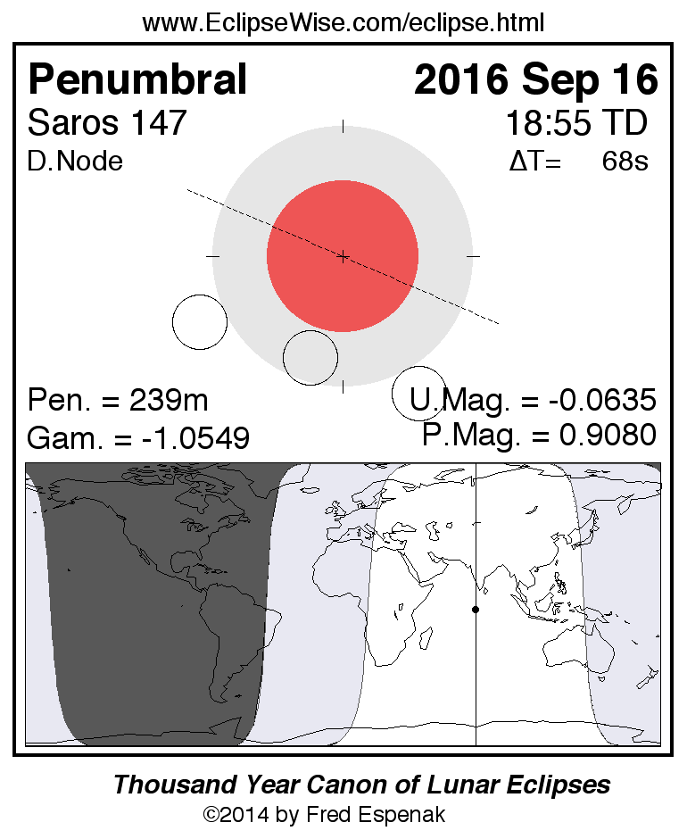
Penumbral Lunar Eclipse of 2016 Sep 16
The final eclipse of 2016 is a deep penumbral lunar eclipse with a magnitude of 0.9082. It should be easily visible to the naked eye as a dusky shading in the northern half of the Moon. The lunar path through Earth’s penumbra and a map illustrating worldwide visibility of the event are shown in Figure 4.
The times of the major phases are listed below.
                              Penumbral Eclipse Begins:     16:54:39 UT1
                              Greatest Eclipse:             18:54:18 UT1
                              Penumbral Eclipse Ends:       20:54:01 UT1
The eclipse occurs at the Moon's descending node in Aquarius near the border with Pisces. At the instant of greatest eclipse (18:54:18 UT1) the Moon lies near the zenith from a location in the Indian Ocean south of India. The event is well placed for observers in Europe, Africa and Asia. None of the eclipse will be visible from North and South America (except for easternmost Brazil).
The September 16 eclipse is the 9th eclipse of Saros 147. This series began on 1890 Jul 02 and is composed of 71 lunar eclipses in the following sequence: 8 penumbral, 23 partial, 12 total, 19 partial, and 8 penumbral eclipses (Espenak and Meeus, 2009a). The last eclipse of the series is on 3134 Jul 28.
Complete details for Saros 147 can be found at:
www.EclipseWise.com/lunar/LEsaros/LEsaros147.html
For additional details on this event, see the EclipseWise Prime Page on the Penumbral Lunar Eclipse of 2016 September 16.
Explanatory Information
Solar Eclipse Figures
Lunar Eclipse Figures
Shadow Diameters and Lunar Eclipses
Eclipse Altitudes and Azimuths
The altitude a and azimuth A of the Sun or Moon during an eclipse depend on the time and the observer's geographic coordinates. They are calculated as follows:
         h = 15 (GST + UT - α ) + λ
         a = arcsin [sin δ sin φ + cos δ cos h cos φ]
         A = arctan [-(cos δ sin h)/(sin δ cos φ - cos δ cos h sin φ)]

where

         h = hour angle of Sun or Moon
         a = altitude
         A = azimuth
         GST = Greenwich Sidereal Time at 0:00 UT
         UT = Universal Time
         α = right ascension of Sun or Moon
         δ = declination of Sun or Moon
         λ = observer's longitude (east +, west -)
         φ = observer's latitude (north +, south -)
During the eclipses of 2016 , the values for GST and the geocentric Right Ascension and Declination of the Sun or the Moon (at greatest eclipse) are as follows:
                  Eclipse               Date             GST          α            δ

                  Total Solar        2016 Mar 09   11.146   23.322   -4.380
                  Penumbral Lunar        2016 Mar 23   12.093   12.222   -0.306
                  Annular Solar        2016 Sep 01   22.731   10.729    8.061
                  Penumbral Lunar        2016 Sep 16   23.743   23.674   -3.260
Two web based tools that can also be used to calculate the local circumstances for all solar and lunar eclipses visible from any location. They are the Javascript Solar Eclipse Explorer and the Javascript Lunar Eclipse Explorer. The URLs for these tools are:
Javascript Solar Eclipse Explorer: www.EclipseWise.com/solar/JSEX/JSEX-index.html
Javascript Lunar Eclipse Explorer: www.EclipseWise.com/lunar/JLEX/JLEX-index.html
Eclipses During 2017
In 2017, there are two central solar eclipses and two lunar eclipses:
| Eclipses During 2017 | |||
| 2017 Feb 11: Penumbral Lunar Eclipse | |||
| 2017 Feb 26: Annular Solar Eclipse | |||
| 2017 Aug 07: Partial Lunar Eclipse | |||
| 2017 Aug 21: Total Solar Eclipse | |||
| Eclipses During 2017 | |||
|
Penumbral Lunar Eclipse 2017 Feb 11 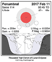
|
Annular Solar Eclipse 2017 Feb 26 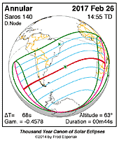
|
Partial Lunar Eclipse 2017 Aug 07 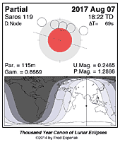
|
Total Solar Eclipse 2017 Aug 21 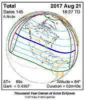
|
A full report Eclipses During 2017 will be published in Observer's Handbook:2017
Eclipse Web Sites
EclipseWise.com is a website dedicated to predictions and information on eclipses of the Sun and Moon. It offers a graphically intuitive interface and contains maps, diagrams, tables, and information about every solar and lunar eclipse from 2000 BCE to 3000 CE. This period includes 11898 solar eclipses and 12064 lunar eclipses.
Much of EclipseWise.com is based on the Thousand Year Canon of Solar Eclipses 1501 to 2500 (Espenak 2014a) and the Thousand Year Canon of Lunar Eclipses 1501 to 2500 (Espenak 2014b). These eclipse predictions use the Jet Propulsion Lab's DE406 — a computer ephemeris used for calculating high precision coordinates of the Sun and Moon for thousands of years into the past and future.
For eclipses over a larger time interval see Five Millennium Canon of Solar Eclipses –1999 to +3000 and Five Millennium Canon of Lunar Eclipses –-1999 to +3000.
The World Atlas of Solar Eclipses provides maps of all central eclipse paths from 2000 BCE to 3000 CE.
MrEclipse.com targets solar and lunar eclipse photography, with tips on eclipse observing and eye safety.
For web versions of this article for other years, visit the following:Eclipse Publications
|

|
|
|
|
|
Acknowledgments
All eclipse predictions were generated on a Macintosh G4 PowerPC using algorithms developed from the Explanatory Supplement [1974] with additional algorithms from Meeus, Grosjean, and Vanderleen [1966]. The solar and lunar coordinates used in the eclipse predictions are based on the JPL DE405. For lunar eclipses, the diameter of the umbral and penumbral shadows were calculated using Danjon's rule of enlarging Earth's radius by 1/85 to compensate for the opacity of the terrestrial atmosphere; corrections for the mean effects of oblateness have also been included.
All calculations, diagrams, tables, and opinions presented in this paper are those of the author, and he assumes full responsibility for their accuracy.
Permission is granted to reproduce the eclipse data when accompanied by a link to this page and an acknowledgment:
"Eclipse Predictions by Fred Espenak, EclipseWise.com"
The use of diagrams and maps is permitted provided that they are unaltered (except for re-sizing) and the embedded credit line is not removed or concealed.
Footnotes
[1] UT1 or Universal Time is the mean solar time on the Prime Meridian at Greenwich, England. Civil time signals are transmitted according to Coordinated Universal Time (UTC), which is based on International Atomic Time (TAI) with leap seconds added at irregular intervals to compensate for the slowing of Earth's rotation. The leap seconds keep UTC within 0.9 second of UT1.
[2] The instant of greatest eclipse occurs when the distance between the Moon's shadow axis and Earth's geocenter reaches a minimum.
[3] Eclipse magnitude for solar eclipses is defined as the fraction of the Sun's diameter occulted by the Moon.
[4] Eclipse obscuration is defined as the fraction of the Sun's area occulted by the Moon.
[5] The Saros is a period of 6,585.3 days (18 years 11 days 8 hours) in which eclipses (both solar and lunar) repeat. The geometry isn't exact but close enough for a Saros series to last 12 or more centuries.
[6] Gamma is the distance of the Moon's shadow axis from Earth's center (in Earth radii) when it reaches its minimum absolute value.
[7] The instant of greatest eclipse for lunar eclipses occurs when the distance between the Moon's shadow axis and Earth's geocenter reaches a minimum.
[8] Penmbral eclipse magnitude is defined as the fraction of the Moon's diameter occulted by Earth’s penumbral shadow.
References
Chauvenet, W., Manual of Spherical and Practical Astronomy, Vol.1, 1891 (Dover edition 1961).
Danjon, A., "Les éclipses de Lune par la pénombre en 1951," L'Astronomie, 65, 51-53 (Feb. 1951).
Espenak, F., Meeus, J., Five Millennium Canon of Solar Eclipses –1999 to +3000, 2nd Edition, AstroPixels Publishing, Portal, AZ, 2021.
Espenak, F., Meeus, J., Five Millennium Canon of Lunar Eclipses –-1999 to +3000, 2nd Edition, AstroPixels Publishing, Portal, AZ, 2021.
Espenak, F., Thousand Year Canon of Solar Eclipses 1501 to 2500, AstroPixels Publishing, Portal, AZ, 2014.
Espenak, F., Thousand Year Canon of Lunar Eclipses 1501 to 2500, AstroPixels Publishing, Portal, AZ, 2014.
Espenak, F., 21st Century Canon of Solar Eclipses, AstroPixels Publishing, Portal, AZ, 2016.
Espenak, F., 21st Century Canon of Lunar Eclipses, AstroPixels Publishing, Portal, AZ, 2020.
Espenak, F., Atlas of Central Solar Eclipses in the USA, AstroPixels Publishing, Portal, AZ, 2016.
Explanatory Supplement to the Astronomical Ephemeris and the American Ephemeris and Nautical Almanac, Her Majesty's Nautical Almanac Office, London, 1974.
Eclipse Publications
|
|
|
|