
2017 Total Solar Eclipse in Kansas
by Fred Espenak
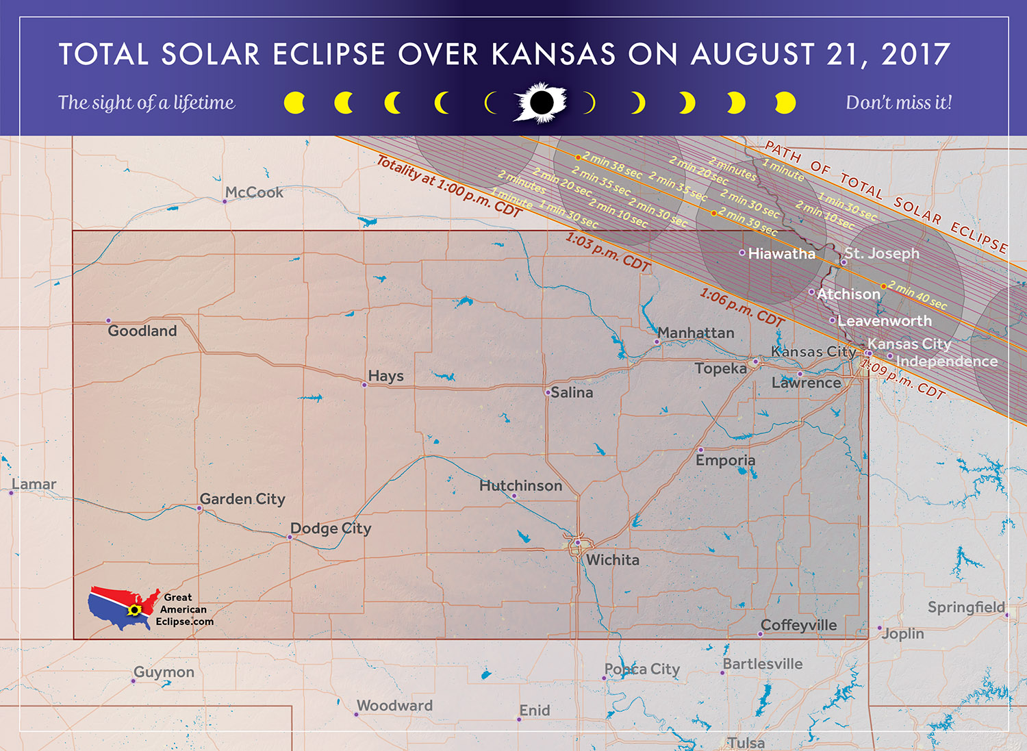
The 2017 Eclipse Path in Kansas
Map courtesy of Michael Zeiler
GreatAmericanEclipse.com
The 2017 Total Solar Eclipse in Kansas
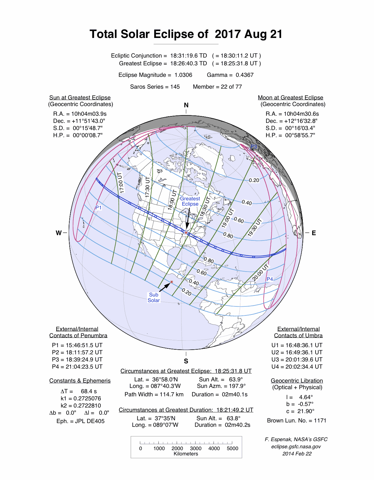
On 2017 August 21, a total eclipse of the Sun is visible from within a narrow corridor that traverses the United States of America. The path of the Moon's umbral shadow begins in northern Pacific and crosses the USA from west to east through parts of the following states: Oregon, Idaho, Wyoming, Nebraska, Kansas, Missouri, Illinois, Kentucky, Tennessee, North Carolina, Georgia, and South Carolina (a tiny corner of Montana and Iowa are also in the path). A partial eclipse visible from a much larger region covering all of North America (See Map).
The Moon's shadow straddles the border between Kansas and Missouri as it leaves Nebraska. Only the northeastern corner of Kansas falls within the umbra's path. Kansas City, the state's third largest city (pop. 148,400), straddles the eclipse track's southern limit. Consequently, the duration of totality ranges from zero (partial eclipse only) to over a minute depending on the observer's exact location. Note that the eastern half of the city is actually in the state of Missouri.
Safe Eclipse Viewing
Every total eclipse of the Sun begins and ends with a partial eclipse. The partial phases require either a projection technique or a special solar filter to be viewed safely. Read more about this at Safe Solar Eclipse Viewing.
Of course during the few brief minutes of Totality when the Sun's disk is completely covered by the Moon, it is then safe to look directly at the Sun with the naked eye or through a telescope or binoculars.
Weather Prospects in Nebraska and Kansas
(Excerpts from Eclipse Bulletin: Total Solar Eclipse of 2017 August 21)
Nebraska and Kansas are states of transition, where the elevation lowers steadily as the eclipse track moves from the High Plains of central and western regions eastward to the Central Lowlands that straddle the Missouri River. The route passes over undulating hills, grassy dunes, occasional buttes and escarpments, rugged Badlands and the rich ecology of intermingled lakes and wetlands. The lunar shadow moves over a gradually descending prairie topography - a countryside of rolling, open hills with none of the complex cloud-making terrain of the Mountain States.
The descent from High Plains to Central Lowlands is matched by a steady increase in atmospheric moisture, which often has its origin over the Gulf of Mexico. Without any topographic barriers to block the winds, the Great Plains and the valleys of the Missouri and Mississippi form an atmospheric highway. Northerly flows are cool and dry, southerlies are humid and hot, westerlies are warm and dry, and easterlies usually mean a low-pressure system has just passed. In middle and upper layers, the westerly flows carry the cool, dried-out remnants of Pacific air across the mountains and onto the Plains. If these westerlies cross a humid, low-level flow of Gulf air, the combination creates the instability that helps initiate the thunderstorms for which the Prairies are so well known.
Interestingly, however, cloudiness tends to decrease during the afternoon across the Great Plains rather than increase, as it does in the mountains. Morning clouds are broken up by solar heating, and so across Nebraska and Kansas cloudiness decreases by ~10% between 7 am and 2 pm. The Moon’s shadow passes across the Plains just before 1 pm CDT, well timed to take advantage of the diurnal trend.
In southeastern Nebraska and northeast Kansas, where the eclipse crosses the Central Lowlands along the Missouri River, the terrain is wide open to sub-tropical moisture reaching northward from the Gulf of Mexico and also subject to extensive evapotranspiration of soil moisture from fields of grain, sorghum, and corn planted on the Prairies. Over the High Plains (toward the Wyoming border), the influx of low-level moisture is held at bay by the rising terrain, limiting the moisture supply for afternoon convective storms on the western side of Nebraska. A consequence of this gradual increase in moisture is reflected in the average August precipitation along the track, which ranges from a low of ~0.3 inches in central Wyoming to 4 inches along the Kansas-Missouri border.
The increase in humidity toward the southeast along the track results in a small, slow increase in average cloud amount across Nebraska, from around 35% to 45% in the west near Alliance, to 50% to 55% in the east around Lincoln and Beatrice. Satellite measurements of average cloudiness along the central line across the state show a similar trend, rising sharply from ~50% near Alliance to nearly 65% at North Platte, whereafter it remains nearly constant. Sunshine measurements along the track are not so pessimistic, showing that North Platte, in central Nebraska, receives 75% of the maximum possible sunshine, while Lincoln and Topeka are content with an average of 70%.
Nebraska is a part of "tornado alley," but by the date of the eclipse, the threat of tornado-producing thunderstorms has declined, from the June peak of 21 to an August average of just 2. Nevertheless, eclipse seekers will still have to contend with the convective climatology of the plains, which tends to be a little less predictable than the large-scale weather systems of other seasons. Thunderstorm frequency increases toward the southeast, into northeast Kansas, where growing storms can tap into the Gulf moisture more readily.
Nebraska favors the well-prepared expedition, as highways in the state permit rapid movement to clearer skies, which are often not too distant when thunderstorms are responsible. Good weather information will be essential - satellite images work particularly well in the short range, but a forecast from the day before will probably prove more convenient.
A good home base for eclipse expeditions is Alliance, NE, or nearby Antioch, both located in the best weather zone on the plains. Highway 2 from Alliance offers 200 miles of in-the-track travel toward the east if cloud avoidance is necessary and a westerly escape can go all the way to Casper and still stay in the umbral region. In central and eastern Nebraska, Interstate 80 allows rapid relocation, cutting diagonally across the track, from Lincoln to Lexington, a distance of 150 miles. Nebraska and northeast Kansas don’t offer any terrain for cloud dissipation, so flight is the best option if a new viewing location is wanted.
A great source of weather forecasts in the days leading up to the eclipse is Jay Anderson's Eclipsophile.com.
Excerpts from Eclipse Bulletin: Total Solar Eclipse of 2017 August 21. This material may not be reproduced without permission.
Fun Facts for the 2017 Total Eclipse in Kansas
- The central line covers a distance of 44 miles across Kansas.
- The average width of the path of totality is 70.2 miles across Kansas.
- The central average line duration of totality is 2 minutes 38 seconds across Kansas.
- The average speed of the Moon's shadow is 1503 mph across Kansas.
- The central line of the eclipse crosses from Kansas into Missouri, then back into Kansas and before finally returning to Missouri. This is because of a big meander in the Missouri River surrounding Rosecrans Memorial Airport in Missouri.
- Before 2017, the last two total solar eclipses visible from Kansas were on 1918 Jun 08 and 1878 Jul 29.
- After 2017, the next two total solar eclipses visible from Kansas will be on 2045 Aug 12 and 2169 Jun 25.
Eclipse Viewing Events and Local Pages in Kansas
- List of Eclipse Viewing Events - American Astronomical Society (AAS)
- List of Eclipse Viewing Events - NationalEclipse.com
- Eclipse Communities in Kansas - Eclipse2017.org
- If you know of other public eclipse viewing events in Kansas, send them to EclipseWise.
- Camp sites at Kansas State Parks can be reserved no more than nine months in advance
(Nov. 17, 2016 is nine months before the eclipse) - Campgrounds run by U.S. Forest Service can be reserved no more than six months in advance
(Feb. 17, 2017 is six months before the eclipse) - The partial phases require either a projection technique or a special solar filter to be viewed safely. On the other hand it is completely safe to watch Totality with the naked eye. For more information see Safe Solar Eclipse Viewing.
Google Map of 2017 Total Eclipse in Kansas
Google Map of 2017 Total Eclipse in Kansas
(Click to use interactive map)
The map above links to an interactive Google map showing the visibility of the Total Solar Eclipse of 2017 Aug 21 in Kansas. The interactive map allows the user to zoom and drag the map as desired. Click the cursor on any location to generate eclipse circumstances from that location.
Eclipse Circumstances for Cities in Kansas
The table below lists eclipse circumstances for a number of cities in Kansas. The following information is given for each city.
- The type of eclipse seen from the city (Partial or Total).
- The times when the partial eclipse begins and ends.
- The times when the total eclipse begins and ends.
- The time of maximum eclipse.
- The altitude on the Sun above the horizon (in degrees) at each of these times.
- The Eclipse Magnitude at maximum eclipse. Eclipse Magnitude is the fraction of the Sun’s diameter occulted by the Moon.
- The Eclipse Obscuration at maximum eclipse. Eclipse obscuration is the fraction of the Sun’s area occulted by the Moon.
- The Duration Total Eclipse is the length of the total phase in minutes and seconds (i.e., totality).
The times appearing in this table include Daylight Saving Time (DST) for all cities in which DST is observed. Report time zone or DST corrections for any city to EclipseWise.
Thanks to Bill Kramer (Eclipse-Chasers.com) for helping to develop the code to generate the above eclipse circumstances table. To calculate predictions for other cities see 2017 Eclipse Circumstances Calculator.
The partial phases require either a projection technique or a special solar filter to be viewed safely. On the other hand it is completely safe to watch Totality with the naked eye. For more information see Safe Solar Eclipse Viewing.
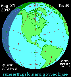
Animation of the Moon's Shadow Across Kansas
The animation above shows the Moon's umbral shadow as it tracks across Kansas. Observers must be inside this path to see the total eclipse. Outside the path only a partial eclipse is seen.
Animation courtesy of Michael Zeiler GreatAmericanEclipse.com.
States in the Path of Totality
The index below gives links to special pages for each of the 12 states in the path of the 2017 total solar eclipse. Note that the eclipse path also crosses a tiny corner of Montana and Iowa, but they are not included in this table.
| States in the Path of Totality | ||
Georgia |
Kentucky |
Oregon |
Idaho |
Missouri |
South Carolina |
Illinois |
Nebraska |
Tennessee |
Kansas |
North Carolina |
Wyoming |
Publications on the 2017 Total Solar Eclipse
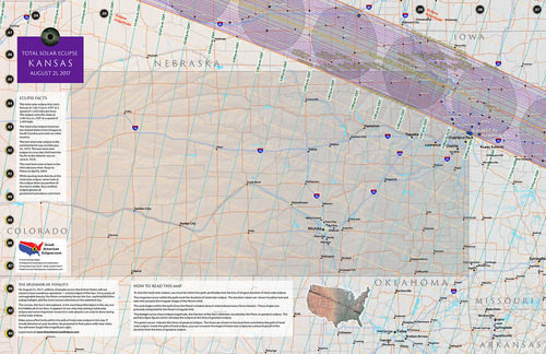
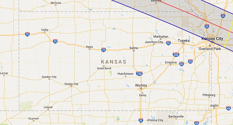
11" x 17" poster map of the 2017 eclipse path through Kansas
(GreatAmericanEclipse.com)
Additional Links for the 2017 Total Solar Eclipse
- Prime Page: Total Solar Eclipse of 2017 Aug 21 - EclipseWise general information on the eclipse
- Special News Page: Total Solar Eclipse of 2017 Aug 21 - major resources and links for the eclipse
- Orthographic Map: Total Solar Eclipse of 2017 Aug 21 - detailed map of eclipse visibility
- Animated Map: Total Solar Eclipse of 2017 Aug 21 - animated map of the Moon's shadows across Earth
- Google Map: Total Solar Eclipse of 2017 Aug 21 - interactive map of the eclipse path
- Path Table: Total Solar Eclipse of 2017 Aug 21 - coordinates of the central line and path limits
- Circumstances Table: Total Solar Eclipse of 2017 Aug 21 - eclipse times for hundreds of cities
- Saros 145 Table - data for all eclipses in the Saros series
- Total Solar Eclipse of 2017 Aug 21 - Google search for links to this eclipse
- 2017 Eclipse - American Astronomical Society (AAS)
- 2017 Eclipse in Kansas - GreatAmericanEclipse.com
- Detailed map of the 2017 eclipse path through Kansas - GreatAmericanEclipse.com
- Eclipse Communities in Kansas - Eclipse2017.org
- Eclipsophile.com - Weather for the 2017 Eclipse

Safe Solar Eclipse Glasses |

Rainbow Symphony Eclipse Shades |

Thousand Oaks Optical Solar Filters |

Great American Eclipse Store |
Links to Additional Solar Eclipse Information
- Home - home page of EclipseWise with predictions for both solar and lunar eclipses
- Solar Eclipses - primary page for solar eclipse predictions
- Solar Eclipse Links - detailed directory of links
- 21st Century Catalog of Solar Eclipses - including the years 2001 to 2100
- Total Solar Eclipses in the USA - maps for all total solar eclipses in the USA from 1001 to 3000
- Annular Solar Eclipses in the USA - maps for all annular solar eclipses in the USA from 1001 to 3000
- Hybrid Solar Eclipses in the USA - maps for all hybrid solar eclipses in the USA from 1001 to 3000
- Javascript Solar Eclipse Explorer - find all solar eclipses visible from a city
- MrEclipse.com - Eclipse resources and tips on photography
- Solar Eclipses for Beginners - a primer on solar eclipse basics
- Safe Solar Eclipse Viewing - summarizes several safe ways to view an eclipse of the Sun
- Solar Filter and Eclipse Glasses - a list of links
- Observing Solar Eclipses Safely - instructions for safely viewing an eclipse of the Sun
- How to Photograph a Solar Eclipse - instructions for imaging an eclipse of the Sun
- MrEclipse Photo Index - an index of solar eclipse photographs
Acknowledgments
Some in the JavaScript code used here is based on the work of Deirdre O'Byrne and Stephen McCann. Bill Kramer (Eclipse-Chasers.com) has expanded this code to work with dozens of cities.
The Besselian elements and values of ΔT used in these calculations are from Eclipse Bulletin: Total Solar Eclipse of 2017 August 21.
Permission is freely granted to reproduce this data when accompanied by an acknowledgment:
"Eclipse Predictions by Fred Espenak (EclipseWise.com)"