
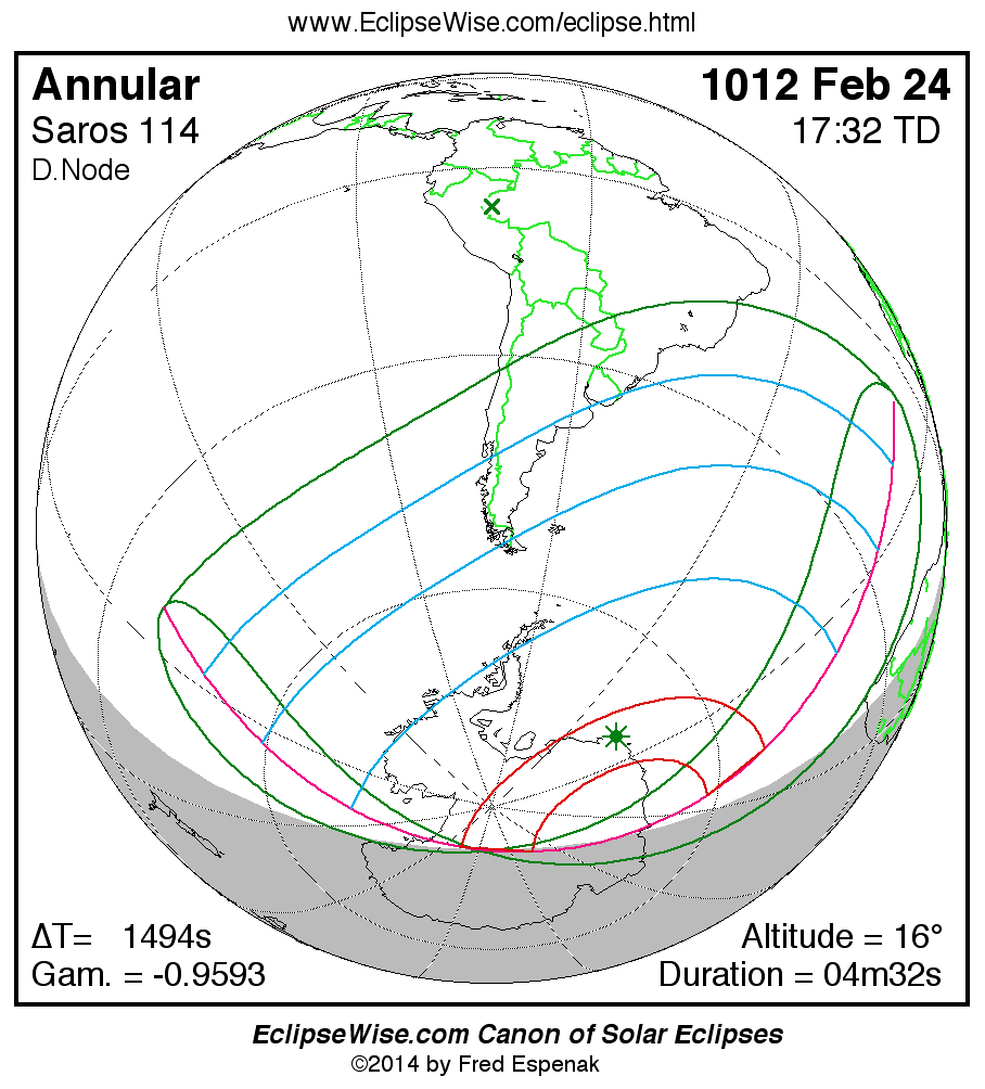
Path of the Annular Solar Eclipse of 1012 Feb 24
Fred Espenak
Introduction
The following table delineates the path of the Moon's antumbral shadow during the Annular Solar Eclipse of 1012 Feb 24 . The geographic coordinates (WGS 84) of the northern and southern limits and the central line are listed at 120-second intervals. This provides adequate detail for making plots of the path on larger scale maps. Local circumstances on the central line include the ratio of the apparent diameters of the Moon to the Sun, the Sun's altitude and azimuth (degrees), the path width (kilometers) and the duration on the central line (minutes and seconds). See the Explanation of the Central Eclipse Path Table for a description of each column in the table.
The geographic visibility of the eclipse is shown on a global map on the Prime Page for the Eclipse which also includes complete details on the eclipse. The path of the eclipse is displayed in greater detail on an interactive Google Map .
| Annular Solar Eclipse of 1012 Feb 24 | |||||||||||
| UT1 | Northern Limit | Southern Limit | Central Line | M:S | Sun | Sun | Path | Central | |||
| Latitude | Longitude | Latitude | Longitude | Latitude | Longitude | Ratio | Alt. | Azm. | Width | Duration | |
| Limits | 82°03.6'S | 136°14.2'E | 80°34.4'S | 074°14.1'E | 82°28.2'S | 107°06.6'E | 0.934 | 0° | - | 973 km | 04m14.4s |
| 16:36 | 86°14.7'S | 052°13.0'W | - | - | 85°02.4'S | 100°33.6'E | 0.934 | 3° | 194° | 941 km | 04m16.9s |
| 16:38 | 84°46.4'S | 045°50.5'W | - | - | 87°26.0'S | 057°55.4'E | 0.935 | 6° | 236° | 897 km | 04m20.3s |
| 16:40 | 83°25.1'S | 041°52.9'W | - | - | 86°53.1'S | 013°31.8'E | 0.936 | 8° | 279° | 873 km | 04m22.4s |
| 16:42 | 82°09.5'S | 038°58.7'W | - | - | 85°30.5'S | 003°46.6'W | 0.936 | 9° | 296° | 857 km | 04m24.1s |
| 16:44 | 80°58.3'S | 036°39.0'W | - | - | 84°05.4'S | 010°33.5'W | 0.936 | 11° | 302° | 845 km | 04m25.4s |
| 16:46 | 79°50.8'S | 034°40.4'W | 82°35.8'S | 054°42.8'E | 82°44.4'S | 013°37.7'W | 0.937 | 12° | 305° | 836 km | 04m26.5s |
| 16:48 | 78°46.4'S | 032°56.2'W | 82°37.9'S | 034°44.6'E | 81°28.2'S | 015°04.7'W | 0.937 | 12° | 305° | 829 km | 04m27.5s |
| 16:50 | 77°44.7'S | 031°22.0'W | 81°52.5'S | 022°34.4'E | 80°16.0'S | 015°42.2'W | 0.937 | 13° | 305° | 825 km | 04m28.3s |
| 16:52 | 76°45.1'S | 029°55.4'W | 80°53.0'S | 015°01.4'E | 79°07.5'S | 015°51.4'W | 0.937 | 14° | 305° | 823 km | 04m29.0s |
| 16:54 | 75°47.5'S | 028°34.4'W | 79°49.2'S | 010°12.8'E | 78°01.8'S | 015°43.1'W | 0.937 | 14° | 304° | 822 km | 04m29.6s |
| 16:56 | 74°51.6'S | 027°17.8'W | 78°44.6'S | 007°05.4'E | 76°58.8'S | 015°23.2'W | 0.937 | 15° | 303° | 822 km | 04m30.2s |
| 16:58 | 73°57.2'S | 026°04.7'W | 77°40.8'S | 005°03.1'E | 75°57.9'S | 014°55.2'W | 0.937 | 15° | 301° | 824 km | 04m30.6s |
| 17:00 | 73°04.0'S | 024°54.2'W | 76°38.0'S | 003°44.9'E | 74°59.0'S | 014°21.2'W | 0.938 | 15° | 300° | 827 km | 04m30.9s |
| 17:02 | 72°12.0'S | 023°45.8'W | 75°36.6'S | 002°58.1'E | 74°01.6'S | 013°42.5'W | 0.938 | 16° | 299° | 831 km | 04m31.2s |
| 17:04 | 71°21.0'S | 022°38.9'W | 74°36.4'S | 002°34.5'E | 73°05.7'S | 013°00.0'W | 0.938 | 16° | 297° | 836 km | 04m31.4s |
| 17:06 | 70°30.9'S | 021°33.1'W | 73°37.4'S | 002°28.9'E | 72°11.0'S | 012°14.3'W | 0.938 | 16° | 296° | 842 km | 04m31.5s |
| 17:08 | 69°41.6'S | 020°28.0'W | 72°39.4'S | 002°38.1'E | 71°17.4'S | 011°25.4'W | 0.938 | 16° | 294° | 849 km | 04m31.5s |
| 17:10 | 68°53.0'S | 019°23.2'W | 71°42.2'S | 002°59.7'E | 70°24.6'S | 010°33.7'W | 0.938 | 16° | 293° | 857 km | 04m31.5s |
| 17:12 | 68°05.0'S | 018°18.5'W | 70°45.7'S | 003°32.6'E | 69°32.7'S | 009°39.1'W | 0.938 | 16° | 291° | 866 km | 04m31.4s |
| 17:14 | 67°17.5'S | 017°13.4'W | 69°49.6'S | 004°16.1'E | 68°41.3'S | 008°41.5'W | 0.937 | 15° | 290° | 875 km | 04m31.2s |
| 17:16 | 66°30.4'S | 016°07.6'W | 68°53.7'S | 005°10.3'E | 67°50.5'S | 007°40.6'W | 0.937 | 15° | 288° | 886 km | 04m30.9s |
| 17:18 | 65°43.7'S | 015°00.9'W | 67°57.8'S | 006°16.0'E | 67°00.0'S | 006°36.1'W | 0.937 | 15° | 286° | 896 km | 04m30.6s |
| 17:20 | 64°57.2'S | 013°52.7'W | 67°01.4'S | 007°34.7'E | 66°09.8'S | 005°27.5'W | 0.937 | 14° | 284° | 908 km | 04m30.1s |
| 17:22 | 64°11.0'S | 012°42.7'W | 66°04.0'S | 009°09.9'E | 65°19.7'S | 004°14.3'W | 0.937 | 14° | 283° | 920 km | 04m29.6s |
| 17:24 | 63°24.8'S | 011°30.4'W | 65°04.7'S | 011°07.6'E | 64°29.4'S | 002°55.4'W | 0.937 | 13° | 281° | 932 km | 04m29.0s |
| 17:26 | 62°38.5'S | 010°15.2'W | 64°01.6'S | 013°41.2'E | 63°38.9'S | 001°29.7'W | 0.937 | 13° | 279° | 944 km | 04m28.2s |
| 17:28 | 61°52.2'S | 008°56.5'W | 62°49.0'S | 017°34.6'E | 62°47.7'S | 000°04.7'E | 0.936 | 12° | 277° | 956 km | 04m27.4s |
| 17:30 | 61°05.5'S | 007°33.4'W | - | - | 61°55.5'S | 001°50.2'E | 0.936 | 11° | 274° | 966 km | 04m26.3s |
| 17:32 | 60°18.4'S | 006°04.8'W | - | - | 61°01.7'S | 003°51.3'E | 0.936 | 10° | 272° | 976 km | 04m25.1s |
| 17:34 | 59°30.6'S | 004°29.2'W | - | - | 60°05.1'S | 006°15.8'E | 0.936 | 8° | 269° | 983 km | 04m23.7s |
| 17:36 | 58°41.8'S | 002°44.4'W | - | - | 59°03.4'S | 009°21.9'E | 0.935 | 6° | 266° | 986 km | 04m21.8s |
| 17:38 | 57°51.4'S | 000°47.1'W | - | - | 57°47.4'S | 014°15.6'E | 0.934 | 3° | 261° | 981 km | 04m18.8s |
| Limits | 53°09.5'S | 016°56.5'E | 61°25.9'S | 024°59.0'E | 56°45.4'S | 020°11.9'E | 0.933 | 0° | - | 966 km | 04m15.6s |
ΔT = 1493.6 seconds
| Greatest Eclipse and Greatest Duration | ||||||||
| Event | Time TD |
Time UT1 |
Latitude | Longitude | Sun Altitude |
Sun Azimuth |
Path Width | Central Duration |
| Greatest Eclipse | 17:31:51.1 | 17:06:57.5 | 71°45.2'S | 018°05.6'W | 15.8° | 295.1° | 845.2 km | 04m31.53s |
| Greatest Duration | 17:32:51.7 | 17:07:58.1 | 71°18.2'S | 011°26.2'W | 15.7° | 294.4° | 848.8 km | 04m31.54s |
Links for the Annular Solar Eclipse of 1012 Feb 24
Links to Additional Solar Eclipse Predictions
- Home - home page of EclipseWise with predictions for both solar and lunar eclipses
- Solar Eclipses - primary page for solar eclipse predictions
- Solar Eclipse Links - detailed directory of links
Eclipse Predictions
Predictions for the Annular Solar Eclipse of 1012 Feb 24 were generated using the JPL DE406 solar and lunar ephemerides. The lunar coordinates were calculated with respect to the Moon's Center of Mass. Although the predictions are first calculated in Terrestrial Dynamical Time (TD), they are then converted to Universal Time (UT1) as presented here. The parameter ΔT is used to convert between the two times (i.e., UT1 = TD - ΔT). ΔT has a value of 1493.6 seconds for this eclipse. The uncertainty in ΔT is 52.2 seconds corresponding to a standard error in longitude of the eclipse path of ± 0.22°.
Acknowledgments
All eclipse calculations are by Fred Espenak, and he assumes full responsibility for their accuracy.
Permission is granted to reproduce eclipse data when accompanied by a link to this page and an acknowledgment:
"Eclipse Predictions by Fred Espenak, EclipseWise.com"
The use of diagrams and maps is permitted provided that they are unaltered (except for re-sizing) and the embedded credit line is not removed or covered.